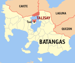
Talisay (Batangas)
| Talisay (Batangas) | |||
|---|---|---|---|
 | |||
| Land | |||
| Status | kommune | ||
| Grunnlagt | 10. februar 1869 | ||
| Oppkalt etter | Terminalia catappa | ||
| Postnummer | 4220 | ||
| Retningsnummer | 43 | ||
| Areal | 28,2 km² | ||
| Befolkning | 46 238[1] (2020) | ||
| Bef.tetthet | 1 639,65 innb./km² | ||
| Antall husholdninger | 10 785 | ||
| Språk | Tagalog | ||
| Høyde o.h. | 227 meter | ||
| Nettside | www | ||
 Talisay (Batangas) 14°06′00″N 121°01′00″Ø | |||

Talisay (Bayan ng Talisay) er en kommune på Filippinene. Kommunen ligger på øya Luzon, og tilhører provinsen Batangas.
Kommunen omfatter områder langs Taalsjøen og halvparten av Volcano Island; det innebærer at en vesentlig del av vulkanen Taal ligger i kommunen.
Barangayer[rediger | rediger kilde]
Talisay er inndelt i 21 barangayer.[2]
- Aya
- Balas
- Banga
- Buco
- Caloocan
- Leynes
- Miranda
- Poblacion Barangay 1
- Poblacion Barangay 2
- Poblacion Barangay 3
- Poblacion Barangay 4
- Poblacion Barangay 5
- Poblacion Barangay 6
- Poblacion Barangay 7
- Poblacion Barangay 8
- Quiling
- Sampaloc
- San Guillermo
- Santa Maria
- Tranca
- Tumaway
Referanser[rediger | rediger kilde]
- ^ «2020 Census of Population and Housing (2020 CPH) Population Counts Declared Official by the President». folketellingen 2020. Filippinenes statistikkbyrå. 7. juli 2021.
- ^ Barangays in Talisay (Batangas) 2018 Philippine Standard Geographic Code (PSGC)
Kilder[rediger | rediger kilde]
- 2015 Census of Population and Housing Report Philippine Statistics Authority
