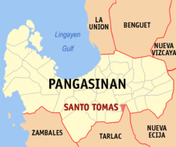
Santo Tomas (Pangasinan)
| Santo Tomas (Pangasinan) | |||
|---|---|---|---|
 | |||
| Land | |||
| Status | kommune | ||
| Postnummer | 2426 | ||
| Retningsnummer | 75 | ||
| Areal | 12,99 km² | ||
| Befolkning | 14 878[1] (2020) | ||
| Bef.tetthet | 1 145,34 innb./km² | ||
| Antall husholdninger | 3 816 | ||
| Språk | Pangasinansk, ilokano, tagalog | ||
| Høyde o.h. | 28 meter | ||
 Santo Tomas (Pangasinan) 15°52′45″N 120°35′18″Ø | |||

Santo Tomas er en kommune i provinsen Pangasinan på øya Luzon på Filippinene. På dens areal på bare 14,3 km² bodde det i 2015 15.022 mennesker,[2] noe som tilsier en folketetthet på 1050 per km².
Barangayer[rediger | rediger kilde]
Santo Tomas er inndelt i ti barangayer:[2]
- La Luna
- Poblacion East
- Poblacion West
- Salvacion
- San Agustin
- San Antonio
- San Jose
- San Marcos
- Santo Domingo
- Santo Niño
Referanser[rediger | rediger kilde]
- ^ «2020 Census of Population and Housing (2020 CPH) Population Counts Declared Official by the President». folketellingen 2020. Filippinenes statistikkbyrå. 7. juli 2021.
- ^ a b Barangays in Santo Tomas (Pangasinan) 2018 Philippine Standard Geographic Code (PSGC)
Kilder[rediger | rediger kilde]
- 2015 Census of Population and Housing Report Philippine Statistics Authority
