Romorantin-Lanthenay
| Romorantin-Lanthenay | |||
|---|---|---|---|
 | |||
| Land | |||
| Region | Centre-Val de Loire | ||
| Departement | Loir-et-Cher | ||
| Arrondissement | Romorantin-Lanthenay | ||
| Status | Kommune | ||
| Postnummer | 41200 | ||
| Areal | 45,32 km²[1] | ||
| Befolkning | 18 115[2] (2021) | ||
| Bef.tetthet | 399,76 innb./km² | ||
| Høyde o.h. | 84 meter | ||
| Nettside | www | ||
 Romorantin-Lanthenay 47°21′30″N 1°44′34″Ø | |||
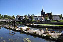
Romorantin-Lanthenay er en kommune og et underprefektur i departementet Loir-et-Cher i regionen Centre-Val de Loire i Frankrike.
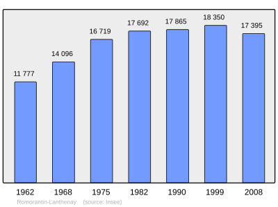
Befolkningsutvikling[rediger | rediger kilde]
Antall innbyggere i kommunen Romorantin-Lanthenay
 |
Referanser[rediger | rediger kilde]
- ^ répertoire géographique des communes, Institut national de l'information géographique et forestière, Wikidata Q20894925, https://geoservices.ign.fr/documentation/diffusion/index.html
- ^ (på fr) Populations légales 2021, INSEE, 28. desember 2023, Wikidata Q124036546, https://www.insee.fr/fr/statistiques/7728826
- ^ Chiffres clés - Évolution et structure de la population
Eksterne lenker[rediger | rediger kilde]
- Offisielt nettsted
- (en) Romorantin-Lanthenay – kategori av bilder, video eller lyd på Commons
- Kommunedata INSEE


