
Fil:Narva basin map.svg

Størrelse for denne PNG-forhåndsvisningen av denne SVG-filen: 423 × 599 piksler Andre oppløsninger: 169 × 240 piksler | 339 × 480 piksler | 542 × 768 piksler | 722 × 1 024 piksler | 1 445 × 2 048 piksler | 743 × 1 053 piksler.
Opprinnelig fil (SVG-fil, standardstørrelse 743 × 1 053 piksler, filstørrelse: 2,46 MB)
| Denne filen er fra Wikimedia Commons og kan brukes av andre prosjekter. Informasjonen fra filbeskrivelsessiden vises nedenfor. |
Beskrivelse
| Beskrivelse |
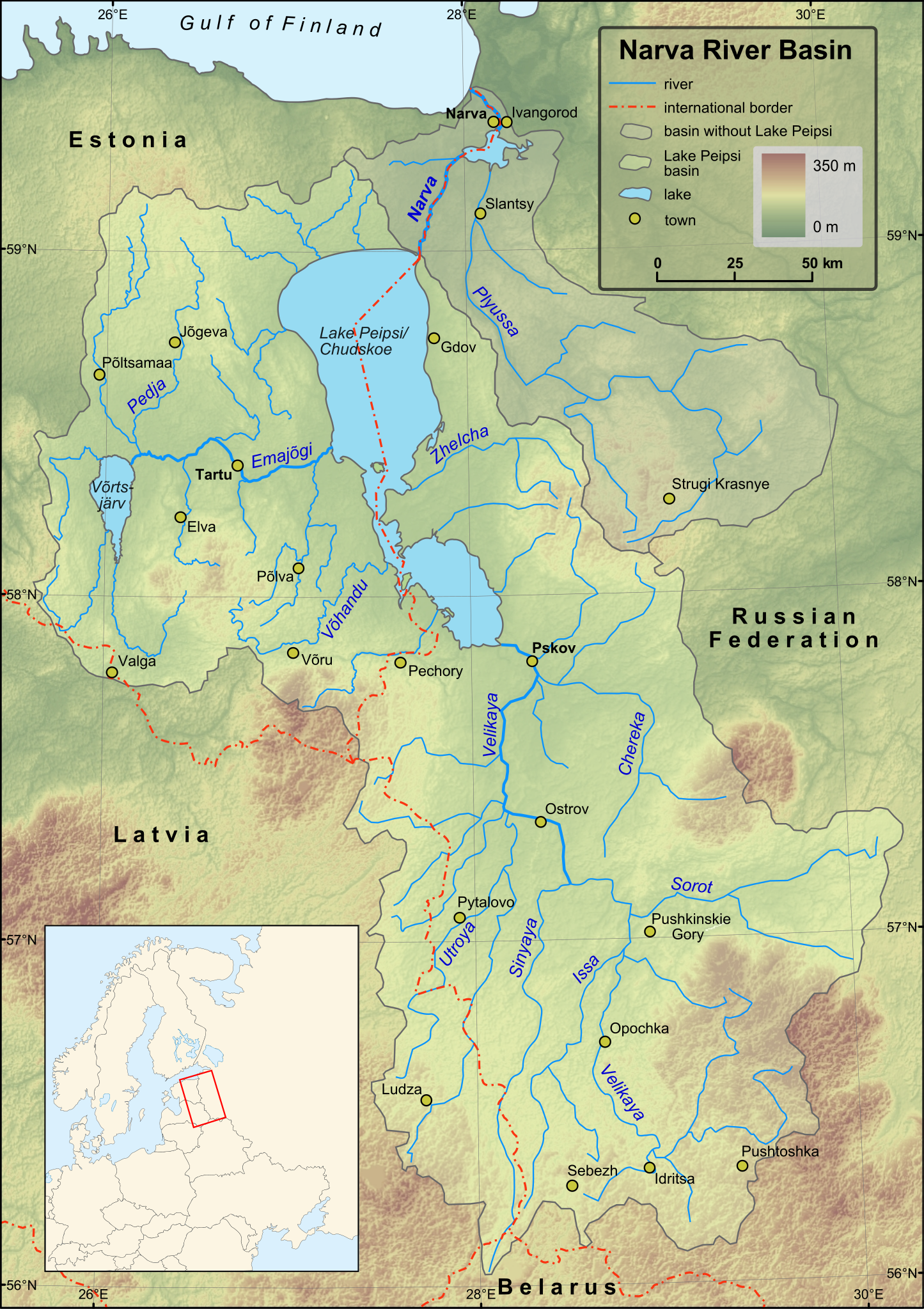
English: Map of Narva River and Lake Peipsi basins. Towns with population over 4000 (according to relevant Wikipedia lists) are included on the map. Terrain: embedded JPG. Projection: UTM Zone 35N |
| Dato | |
| Kilde |
Created in ESRI ArcMap and Inkscape using a map from [1] and some other maps for corrections.
Elevation data from Shuttle Radar Topography Mission. |
| Opphavsperson | Hannu |
| Andre versjoner | Magyar |
Lisensiering
| Jeg, opphavsrettensholderen til dette verket, frigir dette verket til allmennheten. Dette gjelder på verdensbasis. I enkelte land kan dette være juridisk umulig. I så fall: Jeg gir hvem som helst retten til å bruke dette verket for ethvert formål, uten noen vilkår, med mindre slike vilkår kreves ved lov. |
Filhistorikk
Klikk på et tidspunkt for å vise filen slik den var på det tidspunktet.
| Dato/klokkeslett | Miniatyrbilde | Dimensjoner | Bruker | Kommentar | |
|---|---|---|---|---|---|
| nåværende | 1. des. 2009 kl. 18:43 | | 743 × 1 053 (2,46 MB) | Hannu~commonswiki | minor updates |
| 28. nov. 2009 kl. 02:53 |  | 743 × 1 053 (2,44 MB) | Hannu~commonswiki | : | |
| 28. nov. 2009 kl. 02:35 |  | 743 × 1 053 (2,44 MB) | Hannu~commonswiki | text to path | |
| 28. nov. 2009 kl. 02:19 |  | 743 × 1 053 (2,06 MB) | Hannu~commonswiki | : | |
| 28. nov. 2009 kl. 02:14 |  | 743 × 1 053 (2,05 MB) | Hannu~commonswiki | new map | |
| 14. apr. 2009 kl. 20:53 |  | 738 × 1 004 (959 KB) | Hannu~commonswiki | vector location map | |
| 17. jan. 2009 kl. 17:28 |  | 738 × 1 004 (957 KB) | Hannu~commonswiki | {{Information |Description={{en|1=Map of Narva River and Lake Peipsi basins.}} |Source=Created in Inkscape using a map from [http://www.ilec.or.jp/eg/lbmi/pdf/20_Lake_Peipsi_Chudskoe_27February2006.pdf]. Location ma | |
| 16. jan. 2009 kl. 18:18 |  | 738 × 1 004 (639 KB) | Hannu~commonswiki | {{Information |Description={{en|1=Map of Narva River and Lake Peipsi basins.}} |Source=Created in Inkscape using a map from [http://www.ilec.or.jp/eg/lbmi/pdf/20_Lake_Peipsi_Chudskoe_27February2006.pdf]. Minimap mad | |
| 16. jan. 2009 kl. 18:11 |  | 738 × 1 004 (529 KB) | Hannu~commonswiki | {{Information |Description={{en|1=Map of Narva River and Lake Peipsi basins.}} |Source=Created in Inkscape using a map from [http://www.ilec.or.jp/eg/lbmi/pdf/20_Lake_Peipsi_Chudskoe_27February2006.pdf]. Minimap mad |
Filbruk
De følgende 3 sidene bruker denne filen:
Global filbruk
Følgende andre wikier bruker denne filen:
- Bruk i af.wikipedia.org
- Bruk i als.wikipedia.org
- Bruk i ar.wikipedia.org
- Bruk i ast.wikipedia.org
- Bruk i azb.wikipedia.org
- Bruk i be-tarask.wikipedia.org
- Bruk i bg.wikipedia.org
- Bruk i ca.wikipedia.org
- Bruk i cs.wikipedia.org
- Bruk i da.wikipedia.org
- Bruk i de.wikipedia.org
- Bruk i el.wikipedia.org
- Bruk i en.wikipedia.org
- Bruk i es.wikipedia.org
- Bruk i fa.wikipedia.org
- Bruk i fi.wikipedia.org
- Luokka:Narvanjoen vesistö
- Velikaja
- Pljussa
- Piusa jõgi
- Narvanjoen vesistöalue
- Luokka:Narvanjoen alue
- Narvanjoen alue
- Janja (Pljussa)
- Ljuta (Pljussa)
- Vjorduga
- Pljussan valuma-alue
- Kureja
- Pihkovanjoki
- Luokka:Velikajan valuma-alue
- Tšerjoha (joki)
- Haanjan ylänkö
- Alūksnen ylänkö
- Želtša
- Velikajan valuma-alue
- Peipsijärven valuma-alue
- Luokka:Peipsijärven valuma-alue
- Peipsijärven alue
- Luokka:Emajoen alue
- Luokka:Võrtsjärven valuma-alue
- Võhandu jõgi
- Emajoen valuma-alue
Vis mer global bruk av denne filen.