
Fil:Piri Reis map of Europe and the Mediterranean Sea.jpg

Opprinnelig fil (2 000 × 1 375 piksler, filstørrelse: 510 KB, MIME-type: image/jpeg)
| Denne filen er fra Wikimedia Commons og kan brukes av andre prosjekter. Informasjonen fra filbeskrivelsessiden vises nedenfor. |
Beskrivelse
| Beskrivelse |
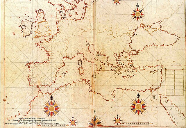
العربية: نسخة عن خريطة تعود لِأواخر القرن السادس عشر الميلادي، منقولة عن الأصل المُنتجة سنة 1525م والمُدرجة ضمن كتاب البحريَّة من تأليف پيري ريِّس
English: a late 16th century copy of the 1525 Kitab-ı Bahriye (Book of Navigation) by Piri Reis |
||||||||||||||||||||
| Dato | late 16th century (Original upload date on en:wikipedia by Flavius Belisarius, 13 August 2007) | ||||||||||||||||||||
| Kilde | Library of Istanbul University. No:6605 | ||||||||||||||||||||
| Opphavsperson |
|
||||||||||||||||||||

|
Derivate Works

Lisensiering
|
Dette verket er offentlig eiendom i Norge, EU og land der den opphavsrettslige vernetiden etter opphavsmannens død er 70 år eller kortere. Merk at noen land har lengre vernetid.
| |
| Denne filen har blitt identifisert til å være fri for kjente restriksjoner under lov om opphavsrett, inkludert alle relaterte og nærstående rettigheter. | |
Filhistorikk
Klikk på et tidspunkt for å vise filen slik den var på det tidspunktet.
| Dato/klokkeslett | Miniatyrbilde | Dimensjoner | Bruker | Kommentar | |
|---|---|---|---|---|---|
| nåværende | 5. aug. 2008 kl. 22:12 | | 2 000 × 1 375 (510 KB) | Xauxa | {{Information |Description=Piri Reis map of Europe, the Mediterranean Sea and North Africa from his Kitab-ı Bahriye (Book of Navigation), 1521-1525 |Source=en:Piri Reis map of Europe and the Mediterranean Sea.jpg |Date=drawn 1513, uploaded on en:wik |
Filbruk
Den følgende siden bruker denne filen:
Global filbruk
Følgende andre wikier bruker denne filen:
- Bruk i ar.wikipedia.org
- بوابة:الدولة العثمانية/صورة
- بوابة:جغرافيا/صورة مختارة/أرشيف
- ويكيبيديا:صور مختارة/رسومات وجداول وخرائط/خرائط
- بيري ريس
- ويكيبيديا:ترشيحات الصور المختارة/خريطة حوض المتوسط لبيري ريس
- ويكيبيديا:صورة اليوم المختارة/سبتمبر 2018
- قالب:صورة اليوم المختارة/2018-09-04
- بوابة:الدولة العثمانية/صورة مختارة/47
- بوابة:جغرافيا/صورة مختارة/14
- ويكيبيديا:صورة اليوم المختارة/يناير 2022
- قالب:صورة اليوم المختارة/2022-01-14
- البرازيل (جزيرة أسطورية)
- Bruk i azb.wikipedia.org
- Bruk i az.wikipedia.org
- Bruk i cs.wikipedia.org
- Bruk i de.wikipedia.org
- Bruk i el.wikipedia.org
- Bruk i en.wikipedia.org
- Bruk i es.wikipedia.org
- Bruk i ga.wikipedia.org
- Bruk i hr.wikipedia.org
- Bruk i id.wikipedia.org
- Bruk i ja.wikipedia.org
- Bruk i nl.wikipedia.org
- Bruk i pl.wikipedia.org
- Bruk i pt.wikipedia.org
- Bruk i ro.wikipedia.org
- Bruk i sh.wikipedia.org
- Bruk i sk.wikipedia.org
- Bruk i sr.wikipedia.org
- Bruk i sv.wikipedia.org
- Bruk i tk.wikipedia.org
Vis mer global bruk av denne filen.