Legazpi
| Legazpi | |||
|---|---|---|---|
 | |||
| Land | |||
| Status | kommune | ||
| Grunnlagt | 1616 | ||
| Oppkalt etter | Miguel Lopez de Legazpi | ||
| Postnummer | 4500 | ||
| Retningsnummer | 52 | ||
| Areal | 153,7 km² | ||
| Befolkning | 209 533[1] (2020) | ||
| Bef.tetthet | 1 363,26 innb./km² | ||
| Antall husholdninger | 46 445 | ||
| Språk | Albay Bikol, tagalog | ||
| Høyde o.h. | 149 meter | ||
| Nettside | legazpi | ||
 Legazpi 13°08′00″N 123°44′00″Ø | |||

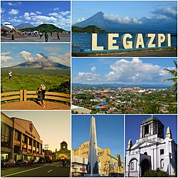
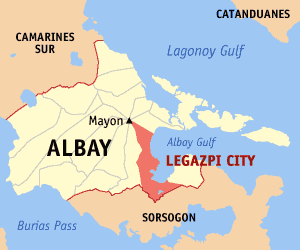
Legazpi (filippinsk: Lungsod ng Legazpi; bikol: Ciudad nin Legazpi) er hovedstad i provinsen Albay på Filippinene. Ved folketellingen i 2015 var befolkningen på 196.639.[2]
Den er en av åtte kommuner som grenser mot den aktive vulkanen Mayon.
Legazpi ble oppkalt etter den spanske conquistador Miguel López de Legazpi som erobret de filippinske øyer i 1565. Hans slektsnavn var i sin tur fra byen Legazpia i det baskiske området Guipuzcoa i Spania.
Barangayer[rediger | rediger kilde]
Legazpi er politisk inndelt i 70 barangayer.[2]
|
|
|
|
Referanser[rediger | rediger kilde]
- ^ «2020 Census of Population and Housing (2020 CPH) Population Counts Declared Official by the President». folketellingen 2020. Filippinenes statistikkbyrå. 7. juli 2021.
- ^ a b Barangays in Legazpi 2018 Philippine Standard Geographic Code (PSGC)
Eksterne lenker[rediger | rediger kilde]
- Offisielt nettsted
- (en) Legazpi, Albay – kategori av bilder, video eller lyd på Commons
