
Fil:Spread sugarcane.JPG
Spread_sugarcane.JPG (483 × 248 piksler, filstørrelse: 16 KB, MIME-type: image/jpeg)
| Denne filen er fra Wikimedia Commons og kan brukes av andre prosjekter. Informasjonen fra filbeskrivelsessiden vises nedenfor. |

|
Dette bildet bør gjenskapes med hjelp av vektorgrafikk som en SVG-fil. Dette har flere fordeler, se Commons:Media for cleanup for mer informasjon. Hvis en SVG-fil med dette bildet er tilgjengelig, vennligst last den opp. Etter opplasting erstatt denne malen med {{vector version available|nytt bilde.svg}}.
|


Beskrivelse
| Beskrivelse |
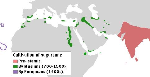
English: Author: User:Bless_sins.
Source: I saw this map in:
Use rationale: I made it myself. The template map was free-use.
(islands west of Africa, circled by violet lines) |
| Dato | 10. april 2008 (original upload date) |
| Kilde |
Transferred from en.wikipedia to Commons by Teratornis using CommonsHelper.
Cambridge University Press. p. 16. |
| Opphavsperson | Bless sins at engelsk Wikipedia |
Lisensiering
- Du står fritt:
- til å dele – til å kopiere, distribuere og overføre verket
- til å blande – til å endre verket
- Under de følgende betingelsene:
- navngivelse – Du må kreditere verket på passende vis, lenke til lisensen og indikere hvorvidt det har blitt gjort endringer. Du kan gjøre det på enhver rimelig måte, men ikke på en måte som antyder at lisensgiveren støtter deg eller din bruk av verket.
- del på samme vilkår – Dersom du remikser, omarbeider eller på annen måte bygger på dette verket, må du kun distribuere resultatet under den samme eller en samsvarende lisens som denne.
Orginal opplastningslogg
- 2008-04-10 04:58 Bless sins 483×248× (16233 bytes) Author: User:Bless_sins. Source: I saw this map in: Watson, Andrew. ''Agricultural innovation in the early Islamic world''. [[Cambridge University Press]]. p. 16. Looking at it I drew an approximation. Use rationale: I made it myself. The template map was
Filhistorikk
Klikk på et tidspunkt for å vise filen slik den var på det tidspunktet.
| Dato/klokkeslett | Miniatyrbilde | Dimensjoner | Bruker | Kommentar | |
|---|---|---|---|---|---|
| nåværende | 7. okt. 2009 kl. 07:32 | | 483 × 248 (16 KB) | File Upload Bot (Magnus Manske) | {{BotMoveToCommons|en.wikipedia|year={{subst:CURRENTYEAR}}|month={{subst:CURRENTMONTHNAME}}|day={{subst:CURRENTDAY}}}} {{Information |Description={{en|Author: User:Bless_sins. Source: I saw this map in: Watson, Andrew. ''Agricultural innovation in the ea |
Filbruk
Det er ingen sider som bruker denne filen.
Global filbruk
Følgende andre wikier bruker denne filen:
- Bruk i cs.wikipedia.org
- Bruk i el.wikipedia.org
- Bruk i en.wikipedia.org
- Bruk i eo.wikipedia.org
- Bruk i es.wikipedia.org
- Bruk i eu.wikipedia.org
- Bruk i fr.wikipedia.org
- Bruk i he.wikipedia.org
- Bruk i hr.wikipedia.org
- Bruk i hu.wikipedia.org
- Bruk i ja.wikipedia.org
- Bruk i kn.wikipedia.org
- Bruk i ko.wikipedia.org
- Bruk i pa.wikipedia.org
- Bruk i pnb.wikipedia.org
- Bruk i pt.wikipedia.org
- Bruk i sh.wikipedia.org
- Bruk i sr.wikipedia.org