
Fil:Political Map of the Arctic.pdf
Størrelse for denne JPG-forhåndsvisningen av denne PDF-filen: 786 × 600 piksler Andre oppløsninger: 315 × 240 piksler | 629 × 480 piksler | 1 007 × 768 piksler | 1 280 × 977 piksler | 2 560 × 1 953 piksler | 4 770 × 3 639 piksler.
Opprinnelig fil (4 770 × 3 639 piksler, filstørrelse: 11,48 MB, MIME-type: application/pdf)
| Denne filen er fra Wikimedia Commons og kan brukes av andre prosjekter. Informasjonen fra filbeskrivelsessiden vises nedenfor. |
Beskrivelse
| Beskrivelse |
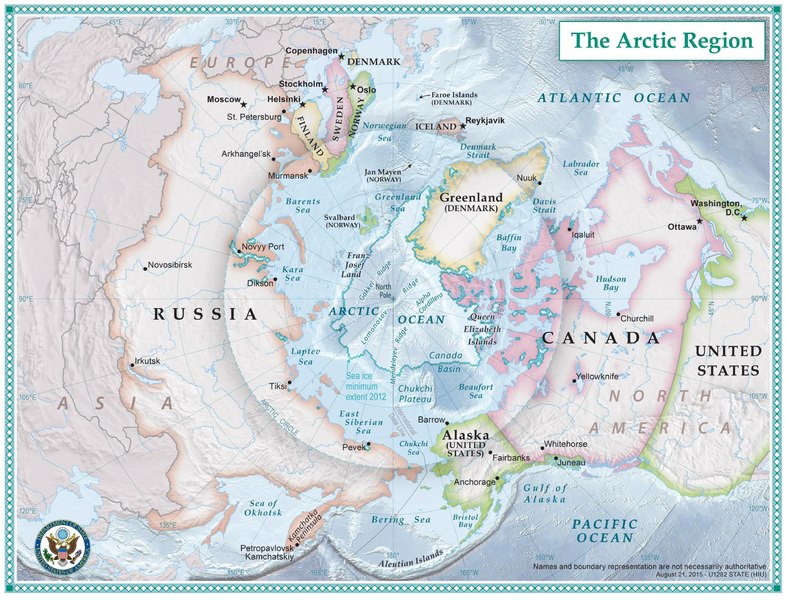
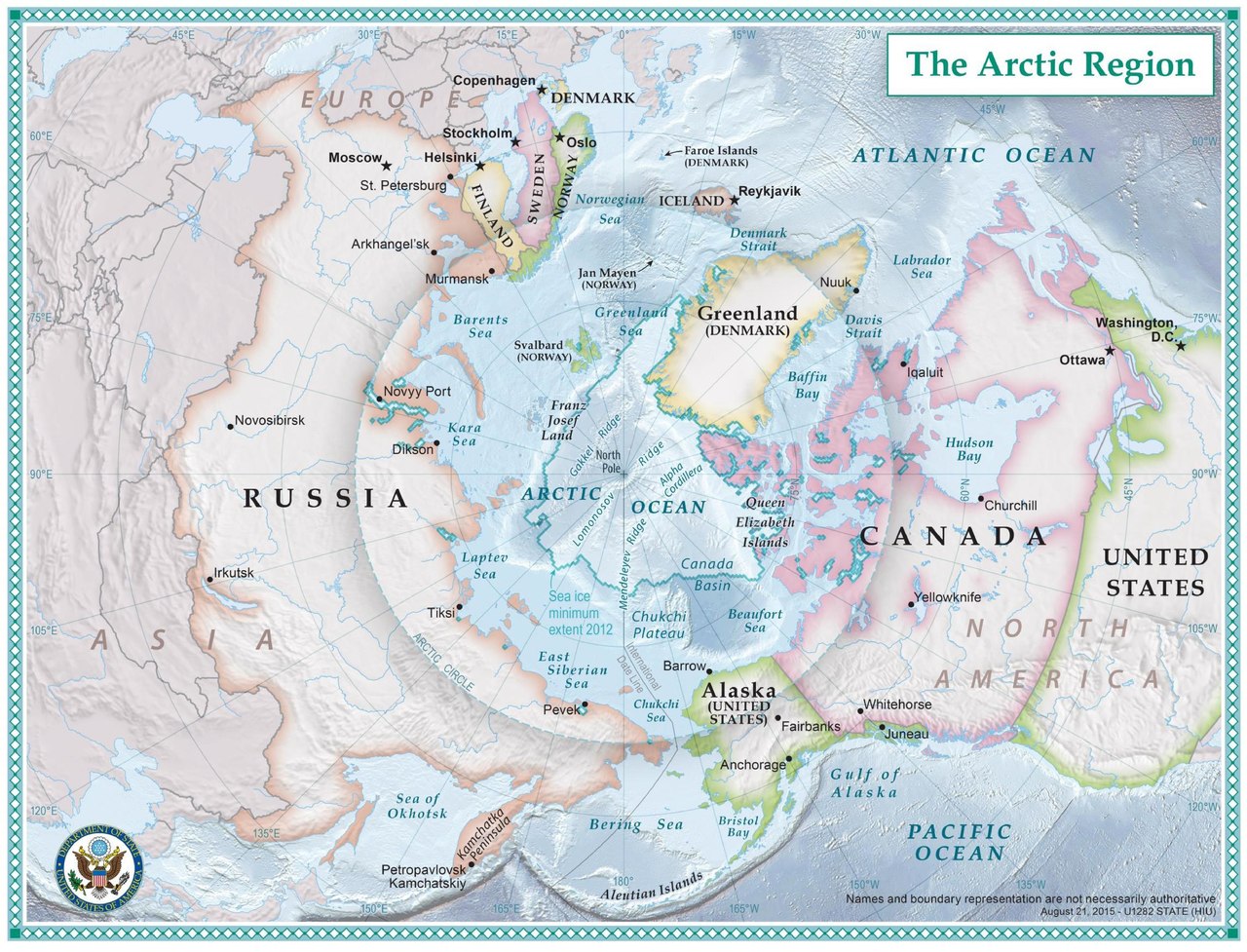
English: The nations which comprise the Arctic region. |
| Dato | ca. 2014 |
| Kilde | https://2009-2017.state.gov/e/oes/ocns/opa/arc/uschair/258202.htm . This map of the Arctic was created by State Department geographers as part of the U.S. Chairmanship of the Arctic Council. |
| Opphavsperson | U.S. State Department |
Lisensiering
This work is in the public domain in the United States because it is a work prepared by an officer or employee of the United States Government as part of that person’s official duties under the terms of Title 17, Chapter 1, Section 105 of the US Code.
Note: This only applies to original works of the Federal Government and not to the work of any individual U.S. state, territory, commonwealth, county, municipality, or any other subdivision. This template also does not apply to postage stamp designs published by the United States Postal Service since 1978. (See § 313.6(C)(1) of Compendium of U.S. Copyright Office Practices). It also does not apply to certain US coins; see The US Mint Terms of Use.
|
 | |
| Denne filen har blitt identifisert til å være fri for kjente restriksjoner under lov om opphavsrett, inkludert alle relaterte og nærstående rettigheter. | ||
Filhistorikk
Klikk på et tidspunkt for å vise filen slik den var på det tidspunktet.
| Dato/klokkeslett | Miniatyrbilde | Dimensjoner | Bruker | Kommentar | |
|---|---|---|---|---|---|
| nåværende | 24. sep. 2016 kl. 20:16 |  | 4 770 × 3 639 (11,48 MB) | Association Chemist | User created page with UploadWizard |
Filbruk
Det er ingen sider som bruker denne filen.
Global filbruk
Følgende andre wikier bruker denne filen:
- Bruk i af.wikipedia.org
- Bruk i ar.wikipedia.org
- Bruk i bn.wikipedia.org
- Bruk i en.wikipedia.org
- Bruk i fa.wikipedia.org
- Bruk i fr.wikipedia.org
- Bruk i ha.wikipedia.org
- Bruk i hr.wikipedia.org
- Bruk i hy.wikipedia.org
- Bruk i id.wikipedia.org
- Bruk i ja.wikipedia.org
- Bruk i mg.wikipedia.org
- Bruk i nds-nl.wikipedia.org
- Bruk i te.wikipedia.org
- Bruk i th.wikipedia.org
- Bruk i tl.wikipedia.org