
Fil:NPS american-samoa-context-map.jpg
Ingen høyere oppløsning tilgjengelig.
NPS_american-samoa-context-map.jpg (471 × 471 piksler, filstørrelse: 40 KB, MIME-type: image/jpeg)
| Denne filen er fra Wikimedia Commons og kan brukes av andre prosjekter. Informasjonen fra filbeskrivelsessiden vises nedenfor. |

|
Dette bildet bør gjenskapes med hjelp av vektorgrafikk som en SVG-fil. Dette har flere fordeler, se Commons:Media for cleanup for mer informasjon. Hvis en SVG-fil med dette bildet er tilgjengelig, vennligst last den opp. Etter opplasting erstatt denne malen med {{vector version available|nytt bilde.svg}}.
|


Beskrivelse
| Beskrivelse |
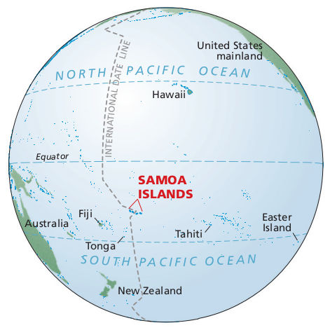
English: Pacific ocean map showing where American Samoa is in relation to the Equator, Fiji, Tahiti, Tonga, Hawaii, and the U.S. mainland – way out there in the Pacific Ocean. |
| Dato | |
| Kilde | U.S. National Park Service (http://npmaps.com/wp-content/uploads/american-samoa-context-map.jpg) |
| Opphavsperson | U.S. National Park Service, restoration/cleanup by Matt Holly |
Lisensiering
| This image or media file contains material based on a work of a National Park Service employee, created as part of that person's official duties. As a work of the U.S. federal government, such work is in the public domain in the United States. See the NPS website and NPS copyright policy for more information. |
Filhistorikk
Klikk på et tidspunkt for å vise filen slik den var på det tidspunktet.
| Dato/klokkeslett | Miniatyrbilde | Dimensjoner | Bruker | Kommentar | |
|---|---|---|---|---|---|
| nåværende | 13. mai 2017 kl. 20:35 | | 471 × 471 (40 KB) | RKBot | =={{int:filedesc}}== {{Information |description= {{en|1=Pacific ocean map showing where American Samoa is in relation to the Equator, Fiji, Tahiti, Tonga, Hawaii, and the U.S. mainland – way out there in the Pacific Ocean.}} |date= 2016-02-22 |source... |
Filbruk
Det er ingen sider som bruker denne filen.
Global filbruk
Følgende andre wikier bruker denne filen:
- Bruk i en.wikipedia.org