
Fil:Israel - Location Map (2012) - ISR - UNOCHA.svg

Opprinnelig fil (SVG-fil, standardstørrelse 250 × 250 piksler, filstørrelse: 141 KB)
| Denne filen er fra Wikimedia Commons og kan brukes av andre prosjekter. Informasjonen fra filbeskrivelsessiden vises nedenfor. |
Beskrivelse
| Beskrivelse |
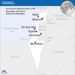
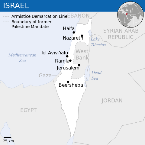
English: Locator map of Israel. العربية: خريطة إسرائيل. |
| Dato | |
| Kilde |
English: [1], OCHA, UNCS |
| Opphavsperson | |
| Andre versjoner |
|
| SVG utvikling | Denne vektorgrafikken ble laget med Inkscape. |
_-_ISR_-_UNOCHA-ar.svg)
_-_ISR_-_UNOCHA-ur.svg)
_-_ISR_-_UNOCHA-zh.svg)
_-_ISR_-_UNOCHA-id.svg)
_-_ISR_-_UNOCHA.svg)
Lisensiering
- Du står fritt:
- til å dele – til å kopiere, distribuere og overføre verket
- til å blande – til å endre verket
- Under de følgende betingelsene:
- navngivelse – Du må kreditere verket på passende vis, lenke til lisensen og indikere hvorvidt det har blitt gjort endringer. Du kan gjøre det på enhver rimelig måte, men ikke på en måte som antyder at lisensgiveren støtter deg eller din bruk av verket.
 This map is part of a collection of 216 free country maps, created by the UN Office for the Coordination of Humanitarian Affairs (OCHA), to be used in print, web or broadcast products.
The ReliefWeb Location Maps released here are maps that highlight a country, its capital, major populated places and the surrounding regions. Attribution Requirements
Using the map without modifications: ensure that the sources and the disclaimer are below the map. Credit as follows: "Credit: OCHA". For use with alteration: remove the OCHA logo and disclaimer following any modification to the map, but keep the data sources as mentioned below the map. Credit the modified map as follows: "Based on OCHA map". You are responsible for the content of your map. We are keen to receive your feedback and hear how you used OCHA's maps. We would be grateful if you would notify us by e-mail and share your work with us. UN Disclaimer
The designations employed and the presentation of material of this map do not imply the expression of any opinion whatsoever on the part of the Secretariat of the United Nations concerning the legal status of any country, territory, city or area or of its authorities or concerning the delimitation of its frontiers or boundaries. |

|
Textual information (e.g. timestamp) once visible in the image itself has been moved into the image metadata and/or image description page. This makes the image easier to reuse and more language-neutral, and makes the text easier to process and search for. Commons discourages placing visible textual information in images. All licenses accepted on Commons permit this type of modification as a derivative work.
If attribution information were removed and the image is not public domain, replace this tag with {{Attribution metadata from licensed image}}.
|
Filhistorikk
Klikk på et tidspunkt for å vise filen slik den var på det tidspunktet.
| Dato/klokkeslett | Miniatyrbilde | Dimensjoner | Bruker | Kommentar | |
|---|---|---|---|---|---|
| nåværende | 8. okt. 2023 kl. 10:26 | | 250 × 250 (141 KB) | Trần Nguyễn Minh Huy | File uploaded using svgtranslate tool (https://svgtranslate.toolforge.org/). Added translation for vi. |
| 27. jul. 2022 kl. 08:39 |  | 250 × 250 (140 KB) | Enkhsaihan2005 | File uploaded using svgtranslate tool (https://svgtranslate.toolforge.org/). Added translation for mn. | |
| 27. jul. 2022 kl. 08:38 |  | 250 × 250 (139 KB) | Enkhsaihan2005 | File uploaded using svgtranslate tool (https://svgtranslate.toolforge.org/). Added translation for mn. | |
| 28. mar. 2022 kl. 03:48 |  | 250 × 250 (136 KB) | Nyilvoskt | File uploaded using svgtranslate tool (https://svgtranslate.toolforge.org/). Added translation for id. | |
| 17. feb. 2022 kl. 17:21 |  | 250 × 250 (134 KB) | Kurmanbek | File uploaded using svgtranslate tool (https://svgtranslate.toolforge.org/). Added translation for tr. | |
| 18. feb. 2016 kl. 00:27 |  | 250 × 250 (130 KB) | Wereldburger758 | Resized page to drawing. Removal watermark. Validation of image. | |
| 19. aug. 2014 kl. 05:21 |  | 250 × 250 (185 KB) | Pharos | == {{int:filedesc}} == {{Information |description={{en|1=Locator map of Chile.}} |date=2013 |source={{en|1=[http://reliefweb.int/map/chile/chile-location-map-2013 Chile Locator Map (ReliefWeb)]}} |author={{en|1=[[w:en:United Nations Offi... |
Filbruk
Det er ingen sider som bruker denne filen.
Global filbruk
Følgende andre wikier bruker denne filen:
- Bruk i ar.wikipedia.org
- Bruk i az.wikipedia.org
- Bruk i ban.wikipedia.org
- Bruk i bcl.wikipedia.org
- Bruk i bh.wikipedia.org
- Bruk i blk.wikipedia.org
- Bruk i bxr.wikipedia.org
- Bruk i dty.wikipedia.org
- Bruk i en.wikipedia.org
- Bruk i es.wikipedia.org
- Bruk i eu.wikipedia.org
- Bruk i fa.wikipedia.org
- Bruk i fr.wikipedia.org
- Bruk i gu.wikipedia.org
- Bruk i hy.wikipedia.org
- Bruk i id.wikipedia.org
- Bruk i incubator.wikimedia.org
- Bruk i ka.wikipedia.org
- Bruk i lo.wikipedia.org
- Bruk i ml.wikipedia.org
- Bruk i mn.wikipedia.org
- Bruk i mzn.wikipedia.org
- Bruk i ne.wikipedia.org
- Bruk i nso.wikipedia.org
- Bruk i pa.wikipedia.org
- Bruk i pnb.wikipedia.org
- Bruk i ro.wikipedia.org
- Bruk i ru.wikipedia.org
- Bruk i sco.wikipedia.org
- Bruk i sd.wikipedia.org
- Bruk i si.wikipedia.org
- Bruk i sl.wikipedia.org
- Bruk i sq.wikipedia.org
- Bruk i su.wikipedia.org
- Bruk i tcy.wikipedia.org
- Bruk i te.wikipedia.org
- Bruk i th.wikipedia.org
- Bruk i to.wikipedia.org
- Bruk i tr.wikipedia.org
Vis mer global bruk av denne filen.
_-_ISR_-_UNOCHA.svg)
_-_ISR_-_UNOCHA.svg)