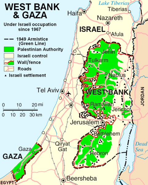
Fil:West Bank & Gaza Map 2007 (Settlements).png

Størrelse på denne forhåndsvisningen: 482 × 599 piksler. Andre oppløsninger: 193 × 240 piksler | 386 × 480 piksler | 780 × 970 piksler.
Opprinnelig fil (780 × 970 piksler, filstørrelse: 86 KB, MIME-type: image/png)
Filhistorikk
Klikk på et tidspunkt for å vise filen slik den var på det tidspunktet.
| Dato/klokkeslett | Miniatyrbilde | Dimensjoner | Bruker | Kommentar | |
|---|---|---|---|---|---|
| nåværende | 30. okt. 2013 kl. 00:55 |  | 780 × 970 (86 KB) | Scott | Correct capitalization in legend. |
| 30. okt. 2013 kl. 00:54 |  | 780 × 970 (86 KB) | Scott | Correct capitalization in legend. | |
| 12. jan. 2009 kl. 08:21 |  | 780 × 970 (105 KB) | HowardMorland | Replace .gif file with identical .png file <!--{{ImageUpload|basic}}--> |
Filbruk
Den følgende siden bruker denne filen:
Global filbruk
Følgende andre wikier bruker denne filen:
- Bruk i am.wikipedia.org
- Bruk i ar.wikipedia.org
- Bruk i ast.wikipedia.org
- Bruk i azb.wikipedia.org
- Bruk i bg.wikipedia.org
- Bruk i ca.wikipedia.org
- Bruk i ckb.wikipedia.org
- Bruk i cs.wikipedia.org
- Bruk i cy.wikipedia.org
- Bruk i da.wikipedia.org
- Bruk i de.wikipedia.org
- Bruk i de.wikinews.org
- Bruk i de.wikivoyage.org
- Bruk i en.wikipedia.org
- Talk:List of ongoing armed conflicts
- User:Timeshifter/Userboxes
- User:Gimmetrow/test
- User:Gimmetrow/test2
- User:Keizers
- Talk:Jerusalem/Archive 15
- Talk:Palestinian National Authority/Archive 2
- Wikipedia:Top 25 Report/July 13 to 19, 2014
- Wikipedia:Top 25 Report/July 20 to 26, 2014
- Wikipedia:Top 25 Report/July 27 to August 2, 2014
- Talk:State of Palestine/Archive 12
- User:Timeshifter/Userboxes/Palestine: Peace Not Apartheid. By Jimmy Carter
- User:Dare2Leap/info
- User:Timeshifter/Archive 2
- Wikipedia talk:WikiProject Israel Palestine Collaboration/Archive 9
- Bruk i en.wikinews.org
- Bruk i eo.wikipedia.org
- Bruk i es.wikipedia.org
- Bruk i eu.wikipedia.org
- Bruk i fa.wikipedia.org
- Bruk i fi.wikipedia.org
- Bruk i fo.wikipedia.org
- Bruk i fr.wikipedia.org
Vis mer global bruk av denne filen.
