Fil:Washington, D.C. locator map.svg
Sideinnholdet støttes ikke på andre språk.
Fra Wikipedia, den frie encyklopedi

Opprinnelig fil(SVG-fil, standardstørrelse 750 × 550 piksler, filstørrelse: 160 KB)


Wikimedia Commons' logo
Beskrivelse
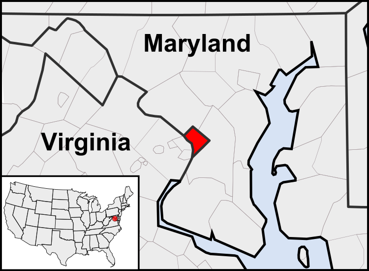
English: This is a map of the location of the District of Columbia showing the borders of states and counties around it.
Dato (UTC)
Kilde
Opphavsperson
Andre versjoner

Derivative works of this file:  United States geographical collation.svg All the below are of the states (and DC) only.
Blank US map.svg Map of states
Labelled US map.svg Map with state labels
USA_blank.svg Image with Hawaii and Alaska in full size
Original blank map of USA and Canada, That image with labels
Original with Hawaii at the natural distance, That original map with labels

File:DC locator map with state names w usmap.png and File:DC locator map with state names.jpg


This is a retouched picture, which means that it has been digitally altered from its original version. Modifications: Cropping to area around District of Columbia. The original can be viewed here: Blank USA, w territories.svg. Modifications made by Patrickneil.

w:no:Creative Commons
navngivelse del på samme vilkår
Denne filen er lisensiert under lisensen Creative Commons Navngivelse-DelPåSammeVilkår 3.0 Unported
Du står fritt:
  • til å dele – til å kopiere, distribuere og overføre verket
  • til å blande – til å endre verket
Under de følgende betingelsene:
  • navngivelse – Du må kreditere verket på passende vis, lenke til lisensen og indikere hvorvidt det har blitt gjort endringer. Du kan gjøre det på enhver rimelig måte, men ikke på en måte som antyder at lisensgiveren støtter deg eller din bruk av verket.
  • del på samme vilkår – Dersom du remikser, omarbeider eller på annen måte bygger på dette verket, må du kun distribuere resultatet under den samme eller en samsvarende lisens som denne.

Orginal opplastningslogg

This image is a derivative work of the following images:

  • File:USA_Counties.svg licensed with PD-USGov-DOC-Census
    • 2007-12-23T15:47:48Z Lokal Profil 555x352 (2124572 Bytes) Fixed state borders and fixed the two parts of Fulton County (Kentucky)
    • 2007-12-10T02:20:23Z Lokal Profil 555x352 (2136501 Bytes) Graphical and code cleanup
    • 2007-12-10T01:15:05Z Lokal Profil 792x612 (2135690 Bytes) First stab at a code cleanup
    • 2006-08-29T00:14:37Z Petr Dlouhý 792x612 (2844548 Bytes) Original file: [[:en:Image:USA CountiesSVG.zip]] This [[ZIP (file format)|ZIP]] file contains an [[SVG]] map of the [[United States]] showing the borders of states and counties in high detail. It was derived from [http://ww
  • File:Blank_USA,_w_territories.svg licensed with Cc-by-sa-3.0-migrated, GFDL
    • 2009-01-30T01:59:59Z Hoshie 959x593 (98189 Bytes) Reverted to version as of 23:58, 14 January 2009 - rv myself; DC can be seen clearly.
    • 2009-01-18T23:34:42Z Hoshie 959x593 (102341 Bytes) Put DC in an inset; fixed Tutuila (American Samoa)
    • 2009-01-14T23:58:05Z Lokal Profil 959x593 (98189 Bytes) Code cleanup and removed stroke from Guam and American Samoa
    • 2009-01-13T05:19:51Z Hoshie 959x593 (101361 Bytes) re did Guam and added American Samoa
    • 2007-12-02T16:08:45Z Lokal Profil 959x593 (88960 Bytes) {{Information |Description=A blank map of the United States including Puerto Rico, Guam, the United States Virgin Islands, and the Northern Mariana Islands. |Source=This version was made by [[:User:Lokal_Profil|Lokal_Profil]]

Uploaded with derivativeFX

Bildetekster

Legg til en kort forklaring på hva filen representerer

Elementer som er med i denne fila

motiv

Filhistorikk

Klikk på et tidspunkt for å vise filen slik den var på det tidspunktet.

(nyeste | eldste) Vis (10 nyere | ) (10 | 20 | 50 | 100 | 250 | 500)
Dato/klokkeslettMiniatyrbildeDimensjonerBrukerKommentar
nåværende23. jul. 2011 kl. 05:23Miniatyrbilde av versjonen fra 23. jul. 2011 kl. 05:23750 × 550 (160 KB)PatrickneilReverted to version as of 03:04, 23 July 2011
23. jul. 2011 kl. 05:21Miniatyrbilde av versjonen fra 23. jul. 2011 kl. 05:21750 × 550 (161 KB)PatrickneilReverted to version as of 03:14, 23 July 2011
23. jul. 2011 kl. 05:20Miniatyrbilde av versjonen fra 23. jul. 2011 kl. 05:20750 × 550 (161 KB)Patrickneilframe
23. jul. 2011 kl. 05:14Miniatyrbilde av versjonen fra 23. jul. 2011 kl. 05:14750 × 550 (161 KB)Patrickneilthicker frame
23. jul. 2011 kl. 05:04Miniatyrbilde av versjonen fra 23. jul. 2011 kl. 05:04750 × 550 (160 KB)Patrickneilstraightening Maryland and Delaware borders
15. aug. 2010 kl. 04:09Miniatyrbilde av versjonen fra 15. aug. 2010 kl. 04:09750 × 550 (202 KB)PatrickneilDelaware River again
15. aug. 2010 kl. 03:51Miniatyrbilde av versjonen fra 15. aug. 2010 kl. 03:51750 × 550 (274 KB)PatrickneilDelaware River border
15. aug. 2010 kl. 03:42Miniatyrbilde av versjonen fra 15. aug. 2010 kl. 03:42750 × 550 (273 KB)Patrickneilforgot border on Smith Island
15. aug. 2010 kl. 03:34Miniatyrbilde av versjonen fra 15. aug. 2010 kl. 03:34750 × 550 (273 KB)Patrickneilcounty borders below state
15. aug. 2010 kl. 03:32Miniatyrbilde av versjonen fra 15. aug. 2010 kl. 03:32750 × 550 (274 KB)Patrickneilchanges by request
(nyeste | eldste) Vis (10 nyere | ) (10 | 20 | 50 | 100 | 250 | 500)

Den følgende siden bruker denne filen:

Global filbruk

Følgende andre wikier bruker denne filen:

Vis mer global bruk av denne filen.