
Fil:Serbia-WW1-4.jpg
Størrelse på denne forhåndsvisningen: 799 × 271 piksler. Andre oppløsninger: 320 × 109 piksler | 1 023 × 347 piksler.
Opprinnelig fil (1 023 × 347 piksler, filstørrelse: 99 KB, MIME-type: image/jpeg)
| Denne filen er fra Wikimedia Commons og kan brukes av andre prosjekter. Informasjonen fra filbeskrivelsessiden vises nedenfor. |

|
This map has been uploaded by Electionworld from en.wikipedia.org to enable the |
Beskrivelse
| Beskrivelse |
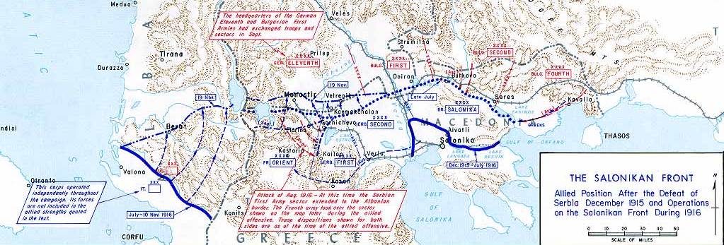
English: Operations at the border of Greece and Serbia, 1916.
his map was created by the Department of Military Art and Engineering, at the U.S. Military Academy (West Point). The initial version was created under the supervision of General Vincent Esposito in 1959. It is now available on the West Point |
||||||
| Dato | |||||||
| Kilde | West Point | ||||||
| Opphavsperson | General Vincent Esposito | ||||||
| Tillatelse (Gjenbruk av denne filen) |
|
||||||
| Andre versjoner |
  |
||||||

Filhistorikk
Klikk på et tidspunkt for å vise filen slik den var på det tidspunktet.
| Dato/klokkeslett | Miniatyrbilde | Dimensjoner | Bruker | Kommentar | |
|---|---|---|---|---|---|
| nåværende | 21. des. 2006 kl. 23:55 | 1 023 × 347 (99 KB) | Electionworld | {{ew|en|Cglassey}} == Summary == Operations at the border of Greece and Serbia, 1916. his map was created by the Department of Military Art and Engineering, at the U.S. Military Academy (West Point). The initial version was created under the supervision |
Filbruk
De følgende 2 sidene bruker denne filen:
Global filbruk
Følgende andre wikier bruker denne filen:
- Bruk i ar.wikipedia.org
- Bruk i azb.wikipedia.org
- Bruk i az.wikipedia.org
- Bruk i be-tarask.wikipedia.org
- Bruk i be.wikipedia.org
- Bruk i bg.wikipedia.org
- Bruk i bs.wikipedia.org
- Bruk i ca.wikipedia.org
- Bruk i de.wikipedia.org
- Bruk i el.wikipedia.org
- Bruk i en.wikipedia.org
- History of modern Macedonia (Greece)
- Maurice Sarrail
- Macedonian front
- Battle of Doiran (1917)
- Greece during World War I
- Monastir offensive
- Autonomous Province of Korçë
- Bulgarian occupation of Albania
- World War I in Albania
- Battle of the Crna Bend (1917)
- User:GerardM/Battles including the Ottoman Empire
- User:Falcaorib
- User:BoDr12/sandbox
- Bruk i es.wikipedia.org
- Bruk i fa.wikipedia.org
- Bruk i fr.wikipedia.org
- Bruk i he.wikipedia.org
- Bruk i hr.wikipedia.org
- Bruk i hu.wikipedia.org
Vis mer global bruk av denne filen.