
Fil:Satellite image of Philippines in March 2002.jpg

Størrelse på denne forhåndsvisningen: 460 × 600 piksler. Andre oppløsninger: 184 × 240 piksler | 368 × 480 piksler | 589 × 768 piksler | 785 × 1 024 piksler | 1 570 × 2 048 piksler | 4 600 × 6 000 piksler.
Opprinnelig fil (4 600 × 6 000 piksler, filstørrelse: 3,58 MB, MIME-type: image/jpeg)
| Denne filen er fra Wikimedia Commons og kan brukes av andre prosjekter. Informasjonen fra filbeskrivelsessiden vises nedenfor. |
Beskrivelse
| Beskrivelse |
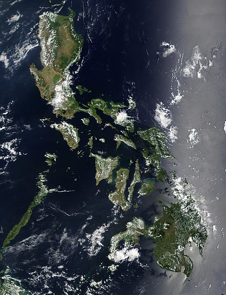
Satellite image of Philippines in March 2002. |
| Dato | |
| Kilde | http://visibleearth.nasa.gov/view_rec.php?id=2689 |
| Opphavsperson | NASA |
Lisensiering
| This file is in the public domain in the United States because it was solely created by NASA. NASA copyright policy states that "NASA material is not protected by copyright unless noted". (See Template:PD-USGov, NASA copyright policy page or JPL Image Use Policy.) | ||
 |
Warnings:
|
Filhistorikk
Klikk på et tidspunkt for å vise filen slik den var på det tidspunktet.
| Dato/klokkeslett | Miniatyrbilde | Dimensjoner | Bruker | Kommentar | |
|---|---|---|---|---|---|
| nåværende | 21. des. 2004 kl. 13:32 | | 4 600 × 6 000 (3,58 MB) | Hautala | {{PD-USGov-NASA}} Satellite image of Philippines in March 2002. Taken from NASA's Visible Earth http://visibleearth.nasa.gov/cgi-bin/viewrecord?12847 . Description: Red dots (or outlines in the high-resolution imagery) indicate MODIS9 detection of thermal |
Filbruk
Den følgende siden bruker denne filen:
Global filbruk
Følgende andre wikier bruker denne filen:
- Bruk i af.wikipedia.org
- Bruk i bg.wikipedia.org
- Bruk i bn.wikipedia.org
- Bruk i ca.wikipedia.org
- Bruk i da.wikipedia.org
- Bruk i de.wikipedia.org
- Bruk i de.wikinews.org
- Bruk i en.wikipedia.org
- Outline of the Philippines
- Deforestation by continent
- Deforestation in the Philippines
- Wikipedia:Featured picture candidates/Satellite image of the Philippines
- Wikipedia:Featured picture candidates/September-2012
- Wikipedia:Featured picture candidates/February-2014
- Wikipedia:Featured picture candidates/Philippines (Satellite)
- Bruk i en.wikiversity.org
- Bruk i en.wiktionary.org
- Bruk i fi.wikipedia.org
- Bruk i gl.wikipedia.org
- Bruk i he.wikipedia.org
- תבנית:הידעת? 5 בנובמבר - סדרה 2
- פורטל:ארצות הברית/הידעת?/קטעי הידעת
- פורטל:ארצות הברית/הידעת?/50
- פורטל:יפן/הידעת?/קטעי הידעת
- תבנית:הידעת? 5 בנובמבר 2014
- ויקיפדיה:הידעת?/2014/נובמבר
- ויקיפדיה:הידעת?/2016/נובמבר
- תבנית:הידעת? 5 בנובמבר 2016
- ויקיפדיה:הידעת?/2018/נובמבר
- תבנית:הידעת? 18 בנובמבר 2018
- תבנית:הידעת? 1 בנובמבר 2019
- ויקיפדיה:הידעת?/2019/נובמבר
- ויקיפדיה:הידעת?/2021/נובמבר
- תבנית:הידעת? 7 בנובמבר 2021
- פורטל:יפן/הידעת?/23
- תבנית:הידעת? 5 בנובמבר 2023
- ויקיפדיה:הידעת?/2023/נובמבר
- Bruk i ht.wikipedia.org
- Bruk i incubator.wikimedia.org
- Bruk i mdf.wikipedia.org
- Bruk i nl.wikipedia.org
- Bruk i nl.wiktionary.org
- Bruk i pap.wikipedia.org
- Bruk i pl.wikinews.org
- Bruk i qu.wikipedia.org
- Bruk i sk.wikipedia.org
- Bruk i sm.wikipedia.org
- Bruk i sr.wikinews.org
- Bruk i trv.wikipedia.org
Vis mer global bruk av denne filen.