
Fil:Qatar municipalities map after 2004 reorganization english.svg

Størrelse for denne PNG-forhåndsvisningen av denne SVG-filen: 344 × 600 piksler Andre oppløsninger: 137 × 240 piksler | 275 × 480 piksler | 440 × 768 piksler | 587 × 1 024 piksler | 1 175 × 2 048 piksler | 459 × 800 piksler.
Opprinnelig fil (SVG-fil, standardstørrelse 459 × 800 piksler, filstørrelse: 134 KB)
| Denne filen er fra Wikimedia Commons og kan brukes av andre prosjekter. Informasjonen fra filbeskrivelsessiden vises nedenfor. |
Beskrivelse
| Beskrivelse |
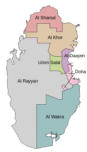
English: Map of the Qatar municipalities after the 2004 reorganization. In English. |
| Dato | |
| Kilde | Self-made using OpenJUMP and Inkscape. Based on Explore Qatar GIS. |
| Opphavsperson | Bamyers99 |
| Andre versjoner |
|

Lisensiering
Jeg, rettighetsinnehaver av dette arbeidet, publiserer det herved under følgende lisens:
| Denne filen er gjort tilgjengelig under lisensen Creative Commons CC0 1.0 Universal Fristatus-erklæring. | |
| Personen som koblet et verk med dette dokumentet har tilegnet arbeidet til allmennheten ved, i den utstrekning loven tillater det, å avstå fra alle de rettigheter vedkommende skulle hatt ifølge opphavsrettsloven og andre relaterte eller nærliggende juridiske rettigheter. Verk under CC0 krever ikke attributtering. Ved bruk av verket trenger du ikke å få godkjennelse fra opphavspersonen.
|
Filhistorikk
Klikk på et tidspunkt for å vise filen slik den var på det tidspunktet.
| Dato/klokkeslett | Miniatyrbilde | Dimensjoner | Bruker | Kommentar | |
|---|---|---|---|---|---|
| nåværende | 22. des. 2011 kl. 23:43 | | 459 × 800 (134 KB) | Bamyers99 | {{Information |Description ={{en|1=Map of the Qatar municipalities after the 2004 reorganization. In English.}} |Source =Self-made using OpenJUMP and Inkscape. Based on [http://www.gisqatar.org.qa/ExploreEN/ Explore Qatar GIS]. |Author |
Filbruk
Den følgende siden bruker denne filen:
Global filbruk
Følgende andre wikier bruker denne filen:
- Bruk i ace.wikipedia.org
- Bruk i az.wikipedia.org
- Bruk i it.wikipedia.org
- Bruk i lez.wikipedia.org
- Bruk i mzn.wikipedia.org
- Bruk i nn.wikipedia.org
- Bruk i uk.wikipedia.org
- Bruk i xmf.wikipedia.org