
Fil:Pavia campaign (1524-25).png
Ingen høyere oppløsning tilgjengelig.
Pavia_campaign_(1524-25).png (459 × 406 piksler, filstørrelse: 401 KB, MIME-type: image/png)
| Denne filen er fra Wikimedia Commons og kan brukes av andre prosjekter. Informasjonen fra filbeskrivelsessiden vises nedenfor. |
.png)

|
Dette bildet bør gjenskapes med hjelp av vektorgrafikk som en SVG-fil. Dette har flere fordeler, se Commons:Media for cleanup for mer informasjon. Hvis en SVG-fil med dette bildet er tilgjengelig, vennligst last den opp. Etter opplasting erstatt denne malen med {{vector version available|nytt bilde.svg}}.
|
Beskrivelse
| Beskrivelse |
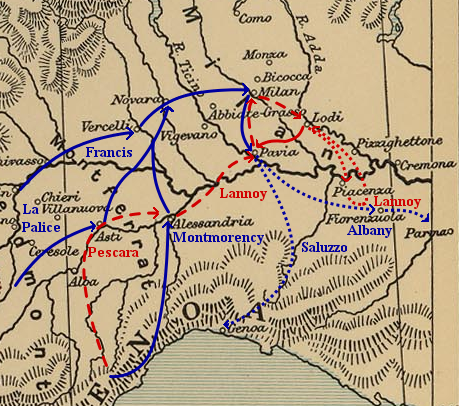
Map of troop movements during the Pavia campaign (1524–25).
|
| Dato | |
| Kilde | Own work based on: Frontiers of France (1521).jpg (a map of the eastern frontiers of France for the period 1521–59, from The Cambridge Modern History Atlas (1912) via the Perry-Castañeda Library Map Collection at the University of Texas) and maps found in Angus Konstam's Pavia 1525: The Climax of the Italian Wars (Oxford: Osprey Publishing, 1996). |
| Opphavsperson | Kirill Lokshin |
| Tillatelse (Gjenbruk av denne filen) |
Public domain as derivative work of a public domain image. |
.jpg)
Lisensiering
| Jeg, opphavsrettensholderen til dette verket, frigir dette verket til allmennheten. Dette gjelder på verdensbasis. I enkelte land kan dette være juridisk umulig. I så fall: Jeg gir hvem som helst retten til å bruke dette verket for ethvert formål, uten noen vilkår, med mindre slike vilkår kreves ved lov. |
This media file is in the public domain in the United States. This applies to U.S. works where the copyright has expired, often because its first publication occurred prior to January 1, 1929, and if not then due to lack of notice or renewal. See this page for further explanation.
|
 | |
 |
This image might not be in the public domain outside of the United States; this especially applies in the countries and areas that do not apply the rule of the shorter term for US works, such as Canada, Mainland China (not Hong Kong or Macao), Germany, Mexico, and Switzerland. The creator and year of publication are essential information and must be provided. See Wikipedia:Public domain and Wikipedia:Copyrights for more details.
|
Filhistorikk
Klikk på et tidspunkt for å vise filen slik den var på det tidspunktet.
| Dato/klokkeslett | Miniatyrbilde | Dimensjoner | Bruker | Kommentar | |
|---|---|---|---|---|---|
| nåværende | 20. jun. 2006 kl. 07:22 | | 459 × 406 (401 KB) | Kirill Lokshin | |
| 20. jun. 2006 kl. 05:26 |  | 459 × 406 (359 KB) | Kirill Lokshin | {{Information |Description= Map of troop movements during the Pavia campaign (1524–25). |Source= Self-made, based on Image:Frontiers of France (1521).jpg and maps found in Angus Konstam's ''Pavia 1525: The Climax of the Italian Wars'' (Oxford: Ospr |
.jpg)
Filbruk
Den følgende siden bruker denne filen:
Global filbruk
Følgende andre wikier bruker denne filen:
- Bruk i ast.wikipedia.org
- Bruk i ca.wikipedia.org
- Bruk i cs.wikipedia.org
- Bruk i de.wikipedia.org
- Bruk i en.wikipedia.org
- Bruk i fr.wikipedia.org
- Bruk i gl.wikipedia.org
- Bruk i hu.wikipedia.org
- Bruk i it.wikipedia.org
- Bruk i ja.wikipedia.org
- Bruk i ko.wikipedia.org
- Bruk i nl.wikipedia.org
- Bruk i pt.wikipedia.org
- Bruk i ru.wikipedia.org
- Bruk i sr.wikipedia.org
- Bruk i tr.wikipedia.org
- Bruk i uk.wikipedia.org
- Bruk i www.wikidata.org
.png)