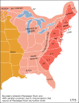
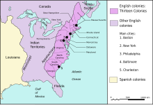
Fil:Map of territorial growth 1775.jpg

Størrelse på denne forhåndsvisningen: 456 × 600 piksler. Andre oppløsninger: 182 × 240 piksler | 570 × 750 piksler.
Opprinnelig fil (570 × 750 piksler, filstørrelse: 172 KB, MIME-type: image/jpeg)
Filhistorikk
Klikk på et tidspunkt for å vise filen slik den var på det tidspunktet.
| Dato/klokkeslett | Miniatyrbilde | Dimensjoner | Bruker | Kommentar | |
|---|---|---|---|---|---|
| nåværende | 30. mar. 2013 kl. 05:07 |  | 570 × 750 (172 KB) | Ras67 | cropped |
| 3. des. 2006 kl. 06:44 |  | 620 × 800 (122 KB) | Dedee73 | The first 13 american colonies | |
| 6. jun. 2005 kl. 23:13 |  | 620 × 800 (122 KB) | Kooma | Map of territorial growth, 1775. From en.wiki. {{PD-USGov-Atlas}} Category:American Revolution |
Filbruk
Den følgende siden bruker denne filen:
Global filbruk
Følgende andre wikier bruker denne filen:
- Bruk i ar.wikipedia.org
- Bruk i az.wikipedia.org
- Bruk i bg.wikipedia.org
- Bruk i bn.wikipedia.org
- Bruk i ca.wikipedia.org
- Bruk i da.wikipedia.org
- Bruk i el.wikipedia.org
- Bruk i en.wikipedia.org
- American cuisine
- Empire
- British North America
- History of the United States (1776–1789)
- Timeline of the American Revolution
- Public Land Survey System
- History of Pennsylvania
- Constitutional history of Canada
- Cultural assimilation of Native Americans
- User:Notuncurious/Working/tmp3
- User:Notuncurious/Working/tmp6
- Aboriginal title in the United States
- Aboriginal title statutes in the Thirteen Colonies
- User:Purplebackpack89/SimpleWikipediaHoftheUS
- Talk:United States Declaration of Independence/Archive 8
- George Washington's political evolution
- User:Lodzdeena/ABŞ tarixi (1776–1789)
- User:Lodzdeena/test
- Bruk i en.wikibooks.org
- Bruk i en.wikiversity.org
- Bruk i fa.wikipedia.org
- Bruk i fr.wikipedia.org
- Bruk i fr.wikisource.org
- Bruk i gl.wikipedia.org
- Bruk i he.wikipedia.org
- Bruk i hu.wikipedia.org
Vis mer global bruk av denne filen.


