
Fil:LocationSouthAfrica-1990.png
Ingen høyere oppløsning tilgjengelig.
LocationSouthAfrica-1990.png (250 × 115 piksler, filstørrelse: 5 KB, MIME-type: image/png)
| Denne filen er fra Wikimedia Commons og kan brukes av andre prosjekter. Informasjonen fra filbeskrivelsessiden vises nedenfor. |

|
En vektorversjon av dette bildet (SVG) er tilgjengelig.
Det bør brukes i stedet for punktgrafikkbildet når det er fordelaktig. File:LocationSouthAfrica-1990.png → File:South Africa in its region (1990).svg
For mer informasjon om vektorgrafikk les Commons transition to SVG. Se også information about MediaWiki's support of SVG images. |
.svg) |
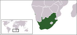
Beskrivelse
A locator map of South Africa showing en:Walvis Bay. This locator map is intended for South African articles taking place before the transfer of Walvis Bay to Namibia in 1994. The orginal map is by Vardion. Since that map is PD, this one is well.
Lisensiering
| Dette verket har blitt frigitt til allmennheten av opphavspersonen Hoshie. Dette gjelder på verdensbasis. I enkelte land kan dette være juridisk umulig. I så fall: |
Filhistorikk
Klikk på et tidspunkt for å vise filen slik den var på det tidspunktet.
| Dato/klokkeslett | Miniatyrbilde | Dimensjoner | Bruker | Kommentar | |
|---|---|---|---|---|---|
| nåværende | 17. des. 2009 kl. 09:26 | | 250 × 115 (5 KB) | Hoshie | Reverted to version as of 03:34, 16 August 2006 rv, Nambia itself wasn't a part of S. Africa |
| 2. des. 2008 kl. 20:37 |  | 250 × 115 (5 KB) | ChrisDHDR | South Africa included Namibia at the time | |
| 16. aug. 2006 kl. 05:34 |  | 250 × 115 (5 KB) | Hoshie | == Summary == A locator map of South Africa showing en:Walvis Bay. This locator map is intended for South African articles taking place before the transfer of Walvis Bay to Nambia in 1994. The orginal map is by [[Us |
Filbruk
Det er ingen sider som bruker denne filen.