
Fil:Lake Whitney & Whitney Dam.jpg

Størrelse på denne forhåndsvisningen: 800 × 533 piksler. Andre oppløsninger: 320 × 213 piksler | 640 × 427 piksler | 1 024 × 683 piksler | 1 500 × 1 000 piksler.
Opprinnelig fil (1 500 × 1 000 piksler, filstørrelse: 234 KB, MIME-type: image/jpeg)
| Denne filen er fra Wikimedia Commons og kan brukes av andre prosjekter. Informasjonen fra filbeskrivelsessiden vises nedenfor. |
| Beskrivelse |
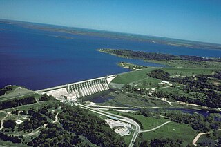
English: Aerial view of Whitney Lake and Dam on the Brazos River in Bosque and Hill Counties, Texas, USA. The river and lake form part of the border between the two counties. The U.S. Army Corps of Engineers constructed the dam in 1951 for flood control and water supply. View is to the north.
Coordinates: 31°51′59.45″N 97°22′15.64″W / 31.8665139°N 97.3710111°W |
|||
| Sted | Bosque and Hill Counties, Texas, USA | |||
| Dato | not specified or unknown | |||
| Kilde |
U.S. Army Corps of Engineers Digital Visual Library Image page Image description page Digital Visual Library home page |
|||
| Opphavsperson | U.S. Army Corps of Engineers, photographer not specified or unknown | |||
| Tillatelse (Gjenbruk av denne filen) |
|
Filhistorikk
Klikk på et tidspunkt for å vise filen slik den var på det tidspunktet.
| Dato/klokkeslett | Miniatyrbilde | Dimensjoner | Bruker | Kommentar | |
|---|---|---|---|---|---|
| nåværende | 19. mai 2007 kl. 03:39 | | 1 500 × 1 000 (234 KB) | DanMS | {{Information | Description = {{en|Aerial view of Whitney Lake and Dam on the Brazos River in Bosque and Hill Counties, Texas, USA. The river and lake form part of the border between the two counties. The U.S. Army Corps of Engineers constructed the da |
Filbruk
Den følgende siden bruker denne filen:
Global filbruk
Følgende andre wikier bruker denne filen:
- Bruk i bo.wikipedia.org
- Bruk i ceb.wikipedia.org
- Bruk i da.wikipedia.org
- Bruk i de.wikipedia.org
- Bruk i en.wikipedia.org
- Bruk i es.wikipedia.org
- Bruk i fa.wikipedia.org
- Bruk i fr.wikipedia.org
- Bruk i ja.wikipedia.org
- Bruk i sv.wikipedia.org
- Bruk i www.wikidata.org