
Fil:Daventry UK locator map.svg

Størrelse for denne PNG-forhåndsvisningen av denne SVG-filen: 524 × 600 piksler Andre oppløsninger: 210 × 240 piksler | 419 × 480 piksler | 671 × 768 piksler | 895 × 1 024 piksler | 1 789 × 2 048 piksler | 1 106 × 1 266 piksler.
Opprinnelig fil (SVG-fil, standardstørrelse 1 106 × 1 266 piksler, filstørrelse: 995 KB)
| Denne filen er fra Wikimedia Commons og kan brukes av andre prosjekter. Informasjonen fra filbeskrivelsessiden vises nedenfor. |
| Beskrivelse |
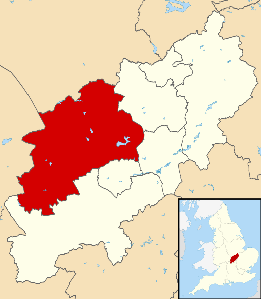
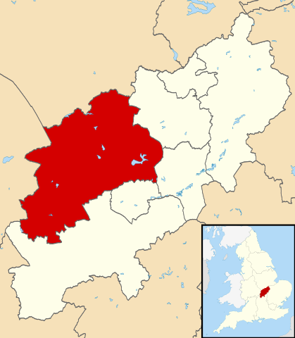
Map of Northamptonshire, UK with Daventry highlighted. Equirectangular map projection on WGS 84 datum, with N/S stretched 160% |
| Dato | |
| Kilde |
|
| Opphavsperson | Nilfanion, created using Ordnance Survey data |
| Tillatelse (Gjenbruk av denne filen) |
Denne filen er lisensiert under lisensen Creative Commons Navngivelse-DelPåSammeVilkår 3.0 Unported Navngivelse: Contains Ordnance Survey data © Crown copyright and database right
|
Filhistorikk
Klikk på et tidspunkt for å vise filen slik den var på det tidspunktet.
| Dato/klokkeslett | Miniatyrbilde | Dimensjoner | Bruker | Kommentar | |
|---|---|---|---|---|---|
| nåværende | 14. aug. 2011 kl. 00:13 | | 1 106 × 1 266 (995 KB) | Nilfanion | {{Information |Description=Map of Northamptonshire, UK with Daventry highlighted. Equirectangular map projection on WGS 84 datum, with N/S stretched 160% |Source=Ordnance Survey [http |
Filbruk
Den følgende siden bruker denne filen:
Global filbruk
Følgende andre wikier bruker denne filen:
- Bruk i bg.wikipedia.org
- Bruk i cy.wikipedia.org
- Bruk i en.wikipedia.org
- Long Buckby
- Braunston
- Naseby
- Daventry
- Althorp
- Daventry District
- East Farndon
- Welford, Northamptonshire
- Crick, Northamptonshire
- Arthingworth
- Ashby St Ledgers
- Badby
- Barby, Northamptonshire
- Boughton, Northamptonshire
- Woodford Halse
- Brixworth
- Brockhall, Northamptonshire
- Byfield, Northamptonshire
- Canons Ashby
- Watford, Northamptonshire
- Yelvertoft
- Winwick, Northamptonshire
- Whilton
- West Haddon
- Walgrave
- Upper Catesby
- Thornby, Northamptonshire
- Teeton
- Sulby, Northamptonshire
- Church Stowe
- Staverton, Northamptonshire
- Spratton
- Sibbertoft
- Scaldwell
- Ravensthorpe, Northamptonshire
- Preston Capes
- Pitsford
- Overstone, Northamptonshire
- Old, Northamptonshire
- Norton, Northamptonshire
- Newnham, Northamptonshire
- Moulton, Northamptonshire
- Marston Trussell
- Maidwell
- Kilsby
- Lamport, Northamptonshire
- Lilbourne
- Little Brington
Vis mer global bruk av denne filen.