Hopp til innhold

Fil:Counties included in Appalachia map.svg

Sideinnholdet støttes ikke på andre språk.
This is a file from the Wikimedia Commons
Fra Wikipedia, den frie encyklopedi

Opprinnelig fil(SVG-fil, standardstørrelse 388 × 417 piksler, filstørrelse: 1,72 MB)


Beskrivelse

Beskrivelse
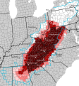
English: Counties included in the cultural definition of Appalachia:
 
Always included in Appalachia
 
Usually included in Appalachia
 
Sometimes included in Appalachia
 
Rarely included in Appalachia
 
Physically contains the Appalachian Mountains or associated features; not culturally Appalachian

The blue dotted line shows the counties included in the w:Appalachian Regional Commission definition
Cities (labeled with dots) are only for reference and are not meant to represent all major cities

Source: from the Mapping Appalachia (https://mapappalachia.geography.vt.edu/about-2/) interactive map viewer: https://www.arcgis.com/home/webmap/viewer.html?webmap=67230740ae2641e9828e48f531cce9a6&extent=-103.5955,26.1117,-60.1995,46.6462 The ten cultural definitions were used: 1896 Berea by William G. Frost and C. Willard Hayes, 1918 Berea Catalog, 1935 USDA Small Region, 1935 USDA Full Region, 1962 Ford Region, 1994 Salstrom, 2002 Core Appalachia from Williams, 1996 Consensus Appalachia from Williams, 1996 Loose Appalachia from Williams

If a county appears in all the definitions, it is marked "always considered", if it appears in at least 6, it is marked "usually considered", if it appears in at least 2, it is marked "sometimes considered", and if it appears in only 1, it is marked "rarely considered"
Dato  Edit this at Structured Data on Commons
Kilde Eget verk Edit this at Structured Data on Commons
Opphavsperson Leviavery Edit this at Structured Data on Commons

Lisensiering

Jeg, rettighetsinnehaver av dette arbeidet, publiserer det herved under følgende lisens:
Creative Commons CC-Zero Denne filen er gjort tilgjengelig under lisensen Creative Commons CC0 1.0 Universal Fristatus-erklæring.
Personen som koblet et verk med dette dokumentet har tilegnet arbeidet til allmennheten ved, i den utstrekning loven tillater det, å avstå fra alle de rettigheter vedkommende skulle hatt ifølge opphavsrettsloven og andre relaterte eller nærliggende juridiske rettigheter. Verk under CC0 krever ikke attributtering. Ved bruk av verket trenger du ikke å få godkjennelse fra opphavspersonen.

Bildetekster

Legg til en kort forklaring på hva filen representerer

Elementer som er med i denne fila

motiv

image/svg+xml

94e2ff809f9d3cc0e9387434d26cdd60f9a06b0e

1 808 572 byte

417 piksel

388 piksel

Filhistorikk

Klikk på et tidspunkt for å vise filen slik den var på det tidspunktet.

Dato/klokkeslettMiniatyrbildeDimensjonerBrukerKommentar
nåværende24. feb. 2024 kl. 21:32Miniatyrbilde av versjonen fra 24. feb. 2024 kl. 21:32388 × 417 (1,72 MB)BrooklaikaRemade the county map in-line with the first half of the description (no original research). While I agree Ohio and Pennsylvania are parts of Appalachia that is not what the sources say
18. jul. 2023 kl. 14:49Miniatyrbilde av versjonen fra 18. jul. 2023 kl. 14:49388 × 417 (1,72 MB)WWWHHHHYYYYYYOops. Didn't remove the outline on one last label. It should be fixed now.
18. jul. 2023 kl. 14:46Miniatyrbilde av versjonen fra 18. jul. 2023 kl. 14:46388 × 417 (1,72 MB)WWWHHHHYYYYYYGoofed the last file with outlines on the text
18. jul. 2023 kl. 14:31Miniatyrbilde av versjonen fra 18. jul. 2023 kl. 14:31388 × 417 (1,72 MB)WWWHHHHYYYYYYUpdated ARC boundaries - Union County, SC plus Cleveland and Catawba Counties, NC are now part of the ARC. Additionally expanded counties which may be included in Appalachia, reflecting the Little Cities of Black Diamonds which are locally identified as Appalachian. Pittsburg's nickname, the Paris of Appalachia, in addition to sources which I will add this file, means Pittsburgh could be considered as part of Appalachia in certain scenarios. Additionally, I have highlighted counties in white...
15. mai 2023 kl. 21:02Miniatyrbilde av versjonen fra 15. mai 2023 kl. 21:02388 × 417 (1,66 MB)LeviaveryScale and text to path
15. mai 2023 kl. 20:57Miniatyrbilde av versjonen fra 15. mai 2023 kl. 20:57259 × 278 (1,51 MB)LeviaveryPittsburg -> Pittsburgh
13. mai 2023 kl. 21:41Miniatyrbilde av versjonen fra 13. mai 2023 kl. 21:41259 × 278 (1,52 MB)LeviaveryAshville -> Asheville
13. mai 2023 kl. 15:53Miniatyrbilde av versjonen fra 13. mai 2023 kl. 15:53259 × 278 (1,64 MB)LeviaveryUploaded own work with UploadWizard

Den følgende siden bruker denne filen:

Global filbruk

Følgende andre wikier bruker denne filen:

Metadata