
Fil:Byers-Peninsula-location-map.png

Størrelse på denne forhåndsvisningen: 800 × 548 piksler. Andre oppløsninger: 320 × 219 piksler | 640 × 439 piksler | 1 024 × 702 piksler | 1 280 × 877 piksler | 1 669 × 1 144 piksler.
Opprinnelig fil (1 669 × 1 144 piksler, filstørrelse: 151 KB, MIME-type: image/png)
| Denne filen er fra Wikimedia Commons og kan brukes av andre prosjekter. Informasjonen fra filbeskrivelsessiden vises nedenfor. |
Beskrivelse
| Beskrivelse |
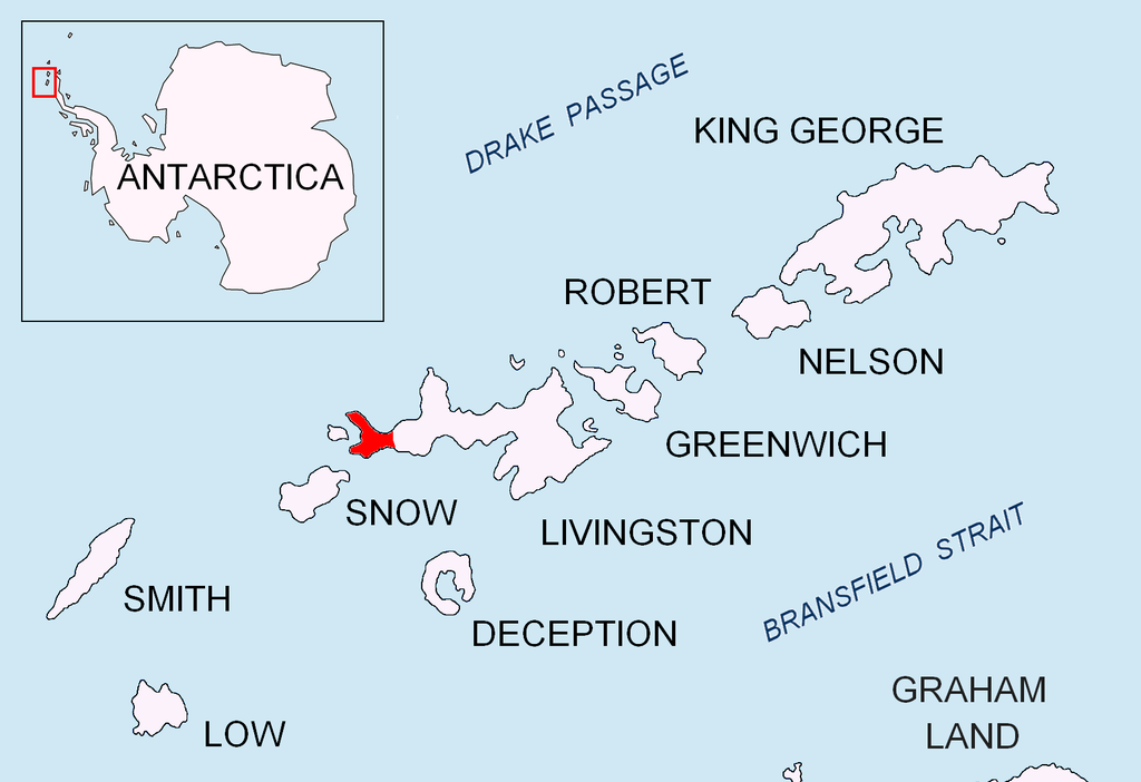
English: Location of Byers Peninsula on Livingston Island in the South Shetland Islands. |
| Dato | |
| Kilde | Eget verk |
| Opphavsperson | Apcbg |
Lisensiering
Jeg, rettighetsinnehaver av dette arbeidet, publiserer det herved under følgende lisenser:
Denne filen er lisensiert under lisensen Creative Commons Navngivelse-DelPåSammeVilkår 3.0 Unported
- Du står fritt:
- til å dele – til å kopiere, distribuere og overføre verket
- til å blande – til å endre verket
- Under de følgende betingelsene:
- navngivelse – Du må kreditere verket på passende vis, lenke til lisensen og indikere hvorvidt det har blitt gjort endringer. Du kan gjøre det på enhver rimelig måte, men ikke på en måte som antyder at lisensgiveren støtter deg eller din bruk av verket.
- del på samme vilkår – Dersom du remikser, omarbeider eller på annen måte bygger på dette verket, må du kun distribuere resultatet under den samme eller en samsvarende lisens som denne.

|
Det tillates at dette dokumentet kopieres, distribueres og/eller modifiseres under retningslinjene som beskrevet i GNU fri dokumentasjonslisens, versjon 1.2 eller senere utgave utgitt av Free Software Foundation; med alle seksjoner, uten noen forsidetekster og baksidetekster. En kopi av lisensen er inkludert i avsnittet GNU Free Documentation License. |
Du kan velge lisens etter eget valg.
Filhistorikk
Klikk på et tidspunkt for å vise filen slik den var på det tidspunktet.
| Dato/klokkeslett | Miniatyrbilde | Dimensjoner | Bruker | Kommentar | |
|---|---|---|---|---|---|
| nåværende | 24. aug. 2010 kl. 18:03 | | 1 669 × 1 144 (151 KB) | Apcbg | + location in Antarctica |
| 1. mai 2010 kl. 19:28 |  | 1 669 × 1 144 (5,47 MB) | Apcbg | {{Information |Description={{en|1=Location of Byers Peninsula on Livingston Island in the South Shetland Islands.}} |Source={{own}} |Author=Apcbg |Date=2010-05-01 |Permission= |other_versions= }} Category:Maps of Antarctica |
Filbruk
Den følgende siden bruker denne filen:
Global filbruk
Følgende andre wikier bruker denne filen:
- Bruk i az.wikipedia.org
- Bruk i bg.wikipedia.org
- Bruk i ca.wikipedia.org
- Bruk i ceb.wikipedia.org
- Bruk i en.wikipedia.org
- Nikopol Point
- Svishtov Cove
- Start Point (Livingston Island)
- President Beaches
- Byers Peninsula
- New Plymouth (Livingston Island)
- Devils Point
- Hell Gates
- Robbery Beaches
- Camp Byers
- Raskuporis Cove
- Belene Cove
- Kardzhali Point
- Ograzhden Cove
- Baba Tonka Cove
- Kukuzel Cove
- Sevar Point
- Dometa Point
- Urvich Wall
- Rish Point
- Isbul Point
- Drong Hill
- Dospey Heights
- Voyteh Point
- Aglen Point
- Tsamblak Hill
- Sparadok Point
- Dulo Hill
- Vardim Rocks
- Essex Point
- Chester Cone
- Ray Promontory
Vis mer global bruk av denne filen.