
Fil:Overland-Richmond.png
Størrelse på denne forhåndsvisningen: 392 × 599 piksler. Andre oppløsninger: 157 × 240 piksler | 314 × 480 piksler | 502 × 768 piksler | 670 × 1 024 piksler | 1 594 × 2 436 piksler.
Opprinnelig fil (1 594 × 2 436 piksler, filstørrelse: 769 KB, MIME-type: image/png)
| Denne filen er fra Wikimedia Commons og kan brukes av andre prosjekter. Informasjonen fra filbeskrivelsessiden vises nedenfor. |
Beskrivelse
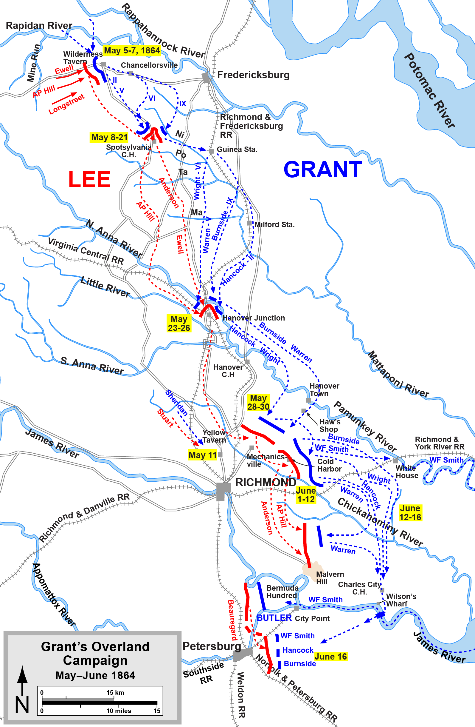
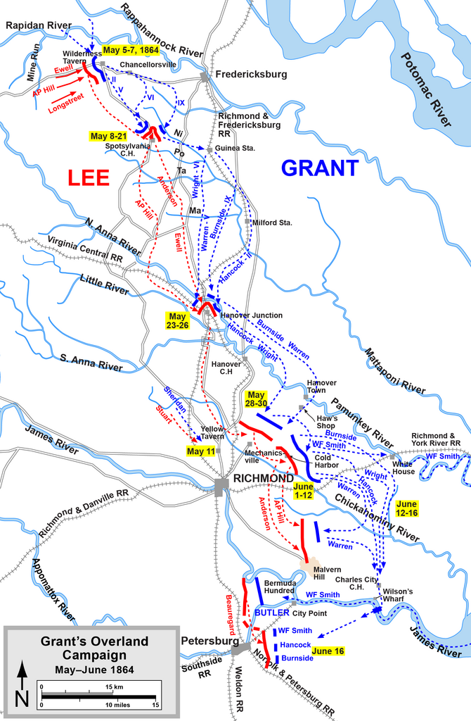
| Beskrivelse | Overland Campaign |
| Kilde | Graphic source file is available at http://www.posix.com/CWmaps/ |
| Opphavsperson | Drawn by Hal Jespersen in Adobe Illustrator CS5. |
Lisensiering
Denne filen er lisensiert under Creative Commons Navngivelse 3.0 Unported
Navngivelse: Map by Hal Jespersen, www.posix.com/CW
- Du står fritt:
- til å dele – til å kopiere, distribuere og overføre verket
- til å blande – til å endre verket
- Under de følgende betingelsene:
- navngivelse – Du må kreditere verket på passende vis, lenke til lisensen og indikere hvorvidt det har blitt gjort endringer. Du kan gjøre det på enhver rimelig måte, men ikke på en måte som antyder at lisensgiveren støtter deg eller din bruk av verket.
Filhistorikk
Klikk på et tidspunkt for å vise filen slik den var på det tidspunktet.
| Dato/klokkeslett | Miniatyrbilde | Dimensjoner | Bruker | Kommentar | |
|---|---|---|---|---|---|
| nåværende | 17. apr. 2011 kl. 00:12 | | 1 594 × 2 436 (769 KB) | Hlj | Add a label for Wilson's Wharf. Same license. |
| 6. apr. 2011 kl. 23:45 |  | 1 594 × 2 436 (766 KB) | Hlj | Added some more detail to the road network (needed for a related map). Same license. | |
| 17. mar. 2011 kl. 22:01 |  | 1 594 × 2 436 (739 KB) | Hlj | Minor graphical changes to conform to new ACW map style for roads and rivers. Same license. | |
| 4. aug. 2010 kl. 22:57 |  | 1 607 × 2 436 (667 KB) | Hlj | New version improves accuracy of unit positions and graphic style that matches others in the ACW series. Added legend box. Drawn by Hal Jespersen in Adobe Illustrator CS5. Graphic source file is available at http://www.posix.com/CWmaps/ {{cc-by-3.0|Map by | |
| 16. nov. 2007 kl. 18:00 |  | 757 × 1 165 (716 KB) | Hlj | {{Information |Description=Map of 1864 Overland Campaign |Source=self-made |Date=corrected typo November 16, 2007 |Author= Hlj |Permission= |other_versions= }} | |
| 27. aug. 2006 kl. 09:33 |  | 1 504 × 2 325 (874 KB) | Edmund Ferman |
Filbruk
De følgende 2 sidene bruker denne filen:
Global filbruk
Følgende andre wikier bruker denne filen:
- Bruk i da.wikipedia.org
- Bruk i de.wikipedia.org
- Bruk i es.wikipedia.org
- Bruk i fi.wikipedia.org
- Bruk i fr.wikipedia.org
- Bruk i hu.wikipedia.org
- Bruk i it.wikipedia.org
- Bruk i ja.wikipedia.org
- Bruk i la.wikipedia.org
- Bruk i nl.wikipedia.org
- Bruk i pt.wikipedia.org
- Bruk i ru.wikipedia.org
- Bruk i vi.wikipedia.org