
Fil:Spratly with flags.jpg
Opprinnelig fil (962 × 741 piksler, filstørrelse: 94 KB, MIME-type: image/jpeg)
| Denne filen er fra Wikimedia Commons og kan brukes av andre prosjekter. Informasjonen fra filbeskrivelsessiden vises nedenfor. |

|
Dette bildet bør gjenskapes med hjelp av vektorgrafikk som en SVG-fil. Dette har flere fordeler, se Commons:Media for cleanup for mer informasjon. Hvis en SVG-fil med dette bildet er tilgjengelig, vennligst last den opp. Etter opplasting erstatt denne malen med {{vector version available|nytt bilde.svg}}.
|


| Beskrivelse |
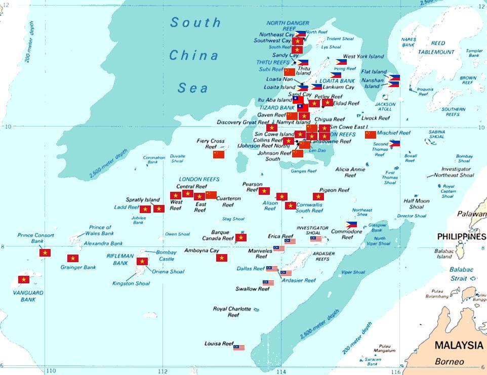
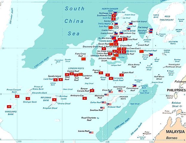
Spratly islands map showing occupied features marked with the flags of countries occupying them.
Kennan Reef (C) The flag nearest the flag for Johnson South Reef (C). |
||||||
| Dato | (Original Picture), February 3, 2008 (Modified Picture) | ||||||
| Kilde | Central Intelligence Agency. | ||||||
| Opphavsperson | CIA. Cropped and Flags added by Estarapapax. | ||||||
| Tillatelse (Gjenbruk av denne filen) |
|
||||||

Filhistorikk
Klikk på et tidspunkt for å vise filen slik den var på det tidspunktet.
| Dato/klokkeslett | Miniatyrbilde | Dimensjoner | Bruker | Kommentar | |
|---|---|---|---|---|---|
| nåværende | 25. mar. 2008 kl. 07:38 | | 962 × 741 (94 KB) | KAVO | {{Information |Description=Spratly islands map showing occupied features marked with the flags of countries occupying them. <br>{{flagicon|Philippines}} Philippines <br>{{flagicon|Taiwan}} Taiwan <br>{{flagicon|Vietnam}} Vietnam <br>{{flagicon|Malaysia}} |
Filbruk
De følgende 2 sidene bruker denne filen:
Global filbruk
Følgende andre wikier bruker denne filen:
- Bruk i az.wikipedia.org
- Bruk i bg.wikipedia.org
- Bruk i ceb.wikipedia.org
- Bruk i cs.wikipedia.org
- Bruk i da.wikipedia.org
- Bruk i de.wikipedia.org
- Bruk i en.wikipedia.org
- Bruk i es.wikipedia.org
- Bruk i et.wikipedia.org
- Bruk i fr.wikipedia.org
- Bruk i hi.wikipedia.org
- Bruk i id.wikipedia.org
- Bruk i ja.wikipedia.org
Vis mer global bruk av denne filen.