
Fil:World population density 1994.png
Størrelse på denne forhåndsvisningen: 800 × 475 piksler. Andre oppløsninger: 320 × 190 piksler | 640 × 380 piksler | 1 024 × 608 piksler | 1 280 × 761 piksler | 2 560 × 1 521 piksler | 6 693 × 3 977 piksler.
Opprinnelig fil (6 693 × 3 977 piksler, filstørrelse: 955 KB, MIME-type: image/png)
| Denne filen er fra Wikimedia Commons og kan brukes av andre prosjekter. Informasjonen fra filbeskrivelsessiden vises nedenfor. |
Beskrivelse
| Beskrivelse |
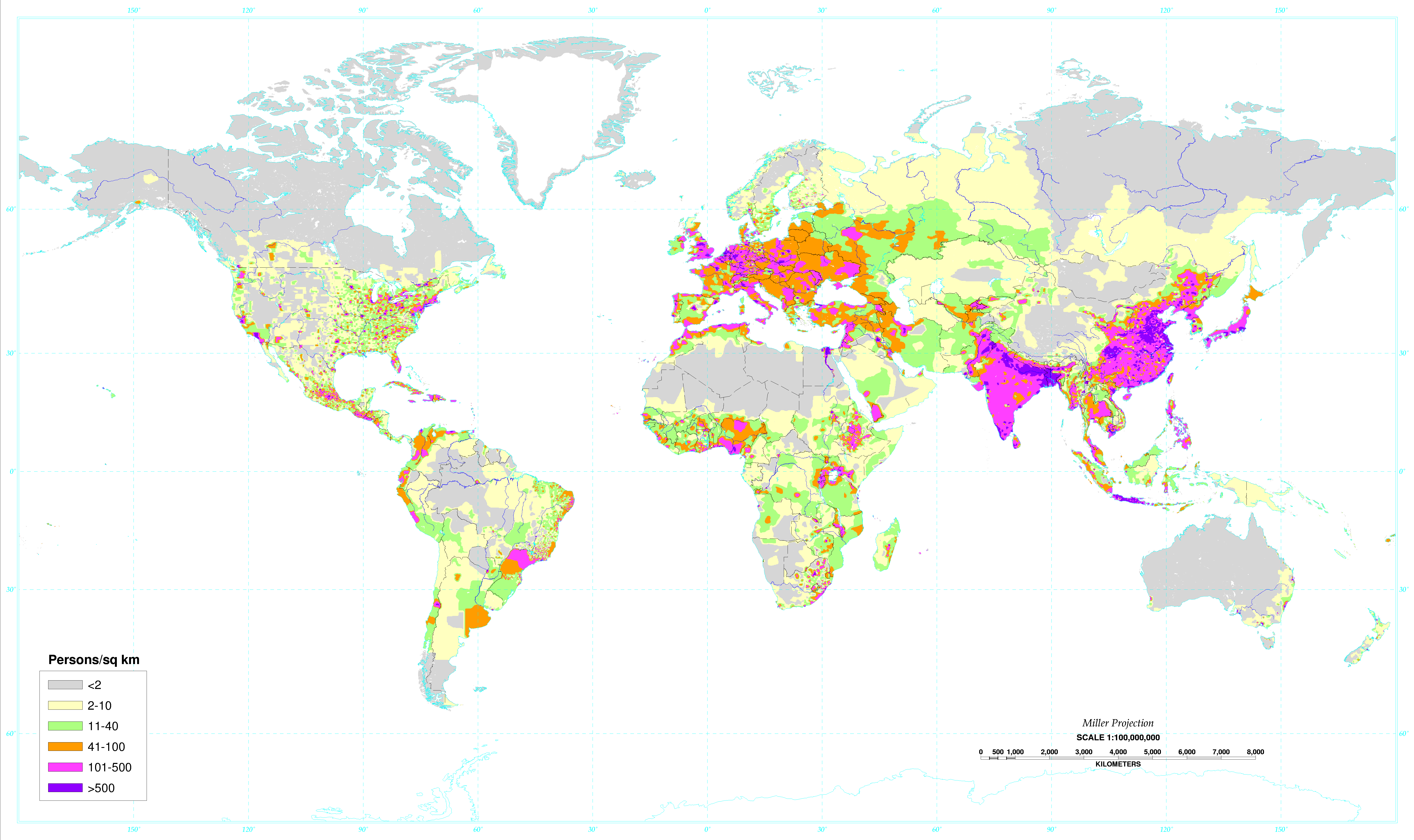
English: World map of the population density in 1994. A more recent population density map can be found at http://sedac.ciesin.columbia.edu/gpw/
Español: Mapa de la densidad de población mundial en 1994. Un mapa de densidad de población más reciente puede verse en http://sedac.ciesin.columbia.edu/gpw/. |
| Dato | Data from 1994. Image made in 2000. |
| Kilde | Global Population Density Map. |
| Opphavsperson | United States Department of Agriculture (USDA) |
| Andre versjoner |
 World population density 1994 - with equator.png |

|
Dette bildet bør gjenskapes med hjelp av vektorgrafikk som en SVG-fil. Dette har flere fordeler, se Commons:Media for cleanup for mer informasjon. Hvis en SVG-fil med dette bildet er tilgjengelig, vennligst last den opp. Etter opplasting erstatt denne malen med {{vector version available|nytt bilde.svg}}.
|
Lisensiering
This work is in the public domain in the United States because it is a work prepared by an officer or employee of the United States Government as part of that person’s official duties under the terms of Title 17, Chapter 1, Section 105 of the US Code.
Note: This only applies to original works of the Federal Government and not to the work of any individual U.S. state, territory, commonwealth, county, municipality, or any other subdivision. This template also does not apply to postage stamp designs published by the United States Postal Service since 1978. (See § 313.6(C)(1) of Compendium of U.S. Copyright Office Practices). It also does not apply to certain US coins; see The US Mint Terms of Use.
|
 | |
| Denne filen har blitt identifisert til å være fri for kjente restriksjoner under lov om opphavsrett, inkludert alle relaterte og nærstående rettigheter. | ||
Filhistorikk
Klikk på et tidspunkt for å vise filen slik den var på det tidspunktet.
| Dato/klokkeslett | Miniatyrbilde | Dimensjoner | Bruker | Kommentar | |
|---|---|---|---|---|---|
| nåværende | 4. mai 2020 kl. 04:34 | | 6 693 × 3 977 (955 KB) | XyKyWyKy | correction - uploaded the wrong file |
| 4. mai 2020 kl. 04:31 |  | 6 693 × 3 977 (954 KB) | XyKyWyKy | color adjustment for better contrast | |
| 5. aug. 2019 kl. 13:31 |  | 6 693 × 3 977 (916 KB) | SinPantuflas | Removed old Panama Canal Zone delimitation from the map. Updated density in Panama Province and Colon (approx). | |
| 7. jan. 2014 kl. 17:18 |  | 6 693 × 3 977 (915 KB) | Nonenmac | Removed the black border, title and publisher info. | |
| 20. okt. 2013 kl. 11:08 |  | 7 021 × 4 543 (951 KB) | McZusatz | RGB from http://soils.usda.gov/use/worldsoils/mapindex/popden-map.zip (uploaded using chunked upload script) | |
| 20. okt. 2013 kl. 10:55 |  | 7 021 × 4 543 (519 KB) | McZusatz | Merging details from duplicate file (uploaded using chunked upload script) | |
| 29. sep. 2013 kl. 22:21 |  | 7 021 × 4 543 (951 KB) | Bürgerentscheid | Reverted to version as of 13:47, 4 September 2011, MediaWiki software now supports PNGs with higher resolution | |
| 4. sep. 2011 kl. 15:47 |  | 1 300 × 841 (166 KB) | Genetics4good | Reverted to version as of 03:04, 2 January 2006 | |
| 4. sep. 2011 kl. 15:47 |  | 7 021 × 4 543 (951 KB) | Genetics4good | Improved resolution, now possible to zoom in much more | |
| 2. jan. 2006 kl. 05:04 |  | 1 300 × 841 (166 KB) | QuartierLatin1968 | From en:Image:World_population_density.gif. World map of the population density in 1994. Made in 2001 by the U.S. departement of agriculture. [http://antwrp.gsfc.nasa.gov/apod/ap030305.html Astronomy Picture of the Day], 2003 March 5. Converted to pn |
Filbruk
Den følgende siden bruker denne filen:
Global filbruk
Følgende andre wikier bruker denne filen:
- Bruk i ast.wikipedia.org
- Bruk i av.wikipedia.org
- Bruk i br.wikipedia.org
- Bruk i ce.wikipedia.org
- Bruk i da.wikipedia.org
- Bruk i da.wikibooks.org
- Bruk i de.wikipedia.org
- Bruk i el.wikipedia.org
- Bruk i en.wikipedia.org
- Bruk i eo.wikipedia.org
- Bruk i es.wikipedia.org
- Bruk i eu.wikipedia.org
- Bruk i fo.wikipedia.org
- Bruk i fr.wikipedia.org
- Bruk i hr.wikipedia.org
- Bruk i hy.wikipedia.org
- Bruk i incubator.wikimedia.org
- Bruk i ja.wikipedia.org
- Bruk i ja.wikibooks.org
- Bruk i ko.wikipedia.org
- Bruk i kw.wikipedia.org
- Bruk i li.wikipedia.org
- Bruk i nl.wikipedia.org
- Bruk i pl.wikipedia.org
- Bruk i pnb.wikipedia.org
- Bruk i ro.wikipedia.org
- Bruk i sq.wikipedia.org
- Bruk i th.wikipedia.org
- Bruk i uk.wikipedia.org
- Bruk i ur.wikipedia.org
- Bruk i vi.wikipedia.org
- Bruk i zh.wikipedia.org