
Fil:Spratly Is since NalGeoMaps.png
Ingen høyere oppløsning tilgjengelig.
Spratly_Is_since_NalGeoMaps.png (330 × 354 piksler, filstørrelse: 31 KB, MIME-type: image/png)
| Denne filen er fra Wikimedia Commons og kan brukes av andre prosjekter. Informasjonen fra filbeskrivelsessiden vises nedenfor. |

|
Dette bildet bør gjenskapes med hjelp av vektorgrafikk som en SVG-fil. Dette har flere fordeler, se Commons:Media for cleanup for mer informasjon. Hvis en SVG-fil med dette bildet er tilgjengelig, vennligst last den opp. Etter opplasting erstatt denne malen med {{vector version available|nytt bilde.svg}}.
|
Beskrivelse
| Beskrivelse |
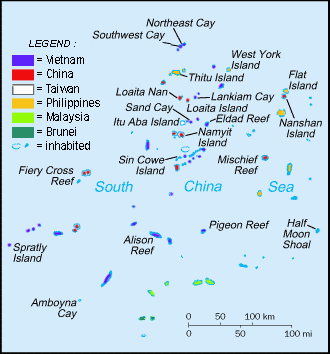
English: Spratly Islands military settlements
Français : Etablissements militaires dans l'archipel des Spratly
Tagalog: Sakop na lupa ng militar sa Pulo ng Kalayaan
中文(简体):南沙群岛的军事区
中文(繁體):南沙群島的軍事區 |
| Dato | |
| Kilde | Cartothèque Spiridon Manoliu |
| Opphavsperson | Spiridon Manoliu |
Lisensiering
| Jeg, opphavsrettensholderen til dette verket, frigir dette verket til allmennheten. Dette gjelder på verdensbasis. I enkelte land kan dette være juridisk umulig. I så fall: Jeg gir hvem som helst retten til å bruke dette verket for ethvert formål, uten noen vilkår, med mindre slike vilkår kreves ved lov. |
Filhistorikk
Klikk på et tidspunkt for å vise filen slik den var på det tidspunktet.
| Dato/klokkeslett | Miniatyrbilde | Dimensjoner | Bruker | Kommentar | |
|---|---|---|---|---|---|
| nåværende | 12. mar. 2021 kl. 08:50 | | 330 × 354 (31 KB) | Mlgc1998 | typo |
| 13. apr. 2015 kl. 13:46 |  | 330 × 354 (18 KB) | RokerHRO | optipng -o7 -i0 → 42.83% decrease | |
| 29. mar. 2009 kl. 16:05 |  | 330 × 354 (32 KB) | Spiridon Ion Cepleanu | {{Information |Description={{en|1=Spratley Islands military settlements}} {{fr|1=Etablissements militaires dans l'archipel des Spratly}} |Source=Cartothèque Spiridon Manoliu |Author=Spiridon Manoliu |Date=March 29, 2009 |Permission= |other_versions= }} |
Filbruk
Den følgende siden bruker denne filen:
Global filbruk
Følgende andre wikier bruker denne filen:
- Bruk i bcl.wikipedia.org
- Bruk i br.wikipedia.org
- Bruk i cs.wikipedia.org
- Bruk i el.wikipedia.org
- Bruk i en.wikipedia.org
- Spratly Islands
- Exclusive economic zone
- Republic of Morac-Songhrati-Meads
- East Sea Campaign
- Philippines and the Spratly Islands
- Template:Spratly Islands
- Spratly Islands dispute
- Dangerous Ground (South China Sea)
- List of maritime features in the Spratly Islands
- List of airports in the Spratly Islands
- DK1 rigs
- Great Wall of Sand
- Bruk i en.wikinews.org
- Bruk i en.wikivoyage.org
- Bruk i fa.wikipedia.org
- Bruk i fi.wikipedia.org
- Bruk i fr.wikipedia.org
- Bruk i fr.wiktionary.org
- Bruk i gl.wikipedia.org
- Bruk i hi.wikipedia.org
- Bruk i id.wikipedia.org
- Bruk i io.wikipedia.org
- Bruk i ja.wikipedia.org
- Bruk i ko.wikipedia.org
- Bruk i pt.wikipedia.org
- Bruk i sv.wikipedia.org
- Bruk i th.wikipedia.org
- Bruk i tr.wikipedia.org
- Bruk i ug.wikipedia.org
- Bruk i vi.wikipedia.org