
Fil:Republic of Congo Map.jpg

Størrelse på denne forhåndsvisningen: 519 × 599 piksler. Andre oppløsninger: 208 × 240 piksler | 416 × 480 piksler | 665 × 768 piksler | 1 034 × 1 194 piksler.
Opprinnelig fil (1 034 × 1 194 piksler, filstørrelse: 265 KB, MIME-type: image/jpeg)
| Denne filen er fra Wikimedia Commons og kan brukes av andre prosjekter. Informasjonen fra filbeskrivelsessiden vises nedenfor. |
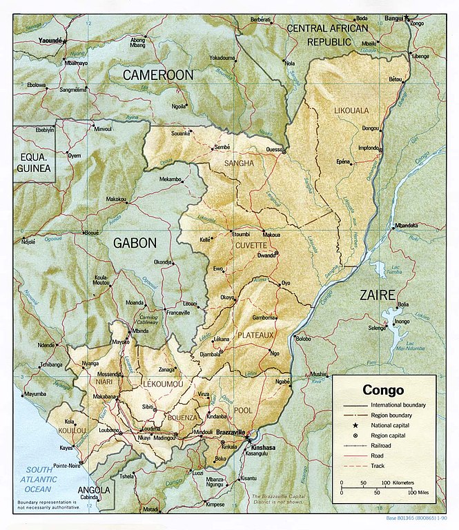
Shaded relief map of the Democratic Republic of the Congo (the former Zaire).
Source: [1] from the Perry-Castañeda Library Map Collection.
![[1]](http://www.lib.utexas.edu/maps/africa/congo_rel90.jpg)
| This image is a work of a Central Intelligence Agency employee, taken or made as part of that person's official duties. As a Work of the United States Government, this image or media is in the public domain in the United States.
|

|
Filhistorikk
Klikk på et tidspunkt for å vise filen slik den var på det tidspunktet.
| Dato/klokkeslett | Miniatyrbilde | Dimensjoner | Bruker | Kommentar | |
|---|---|---|---|---|---|
| nåværende | 16. okt. 2006 kl. 20:53 | | 1 034 × 1 194 (265 KB) | Civvi~commonswiki | Shaded relief map of the Democratic Republic of the Congo (the former Zaire). Source: [http://www.lib.utexas.edu/maps/africa/congo_rel90.jpg] from the [http://www.lib.utexas.edu/maps/africa.html Perry-Castañeda Library Map Collection]. {{PD-USG |
Filbruk
Den følgende siden bruker denne filen:
Global filbruk
Følgende andre wikier bruker denne filen:
- Bruk i bg.wikipedia.org
- Bruk i en.wikipedia.org
- Bruk i fr.wikipedia.org
- Bruk i it.wikipedia.org
- Bruk i ka.wikipedia.org
- Bruk i mg.wikipedia.org
- Bruk i uk.wikipedia.org
- Bruk i vec.wikipedia.org