
Fil:Moss Landing California aerial view.jpg

Størrelse på denne forhåndsvisningen: 800 × 534 piksler. Andre oppløsninger: 320 × 214 piksler | 640 × 427 piksler | 1 024 × 683 piksler | 1 500 × 1 001 piksler.
Opprinnelig fil (1 500 × 1 001 piksler, filstørrelse: 644 KB, MIME-type: image/jpeg)
| Denne filen er fra Wikimedia Commons og kan brukes av andre prosjekter. Informasjonen fra filbeskrivelsessiden vises nedenfor. |
| Beskrivelse |
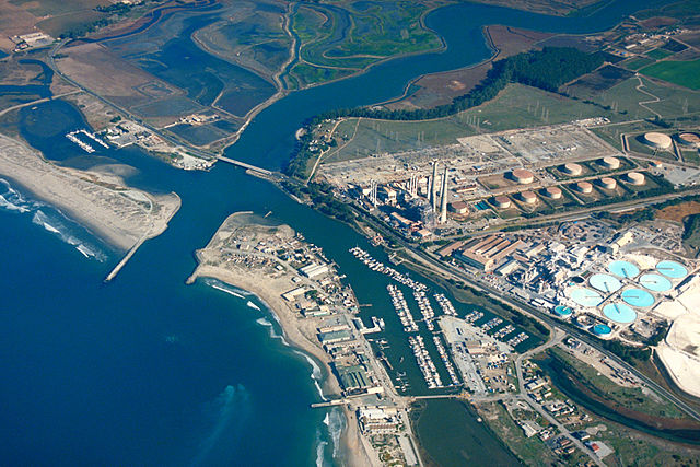
English: Aerial view of Moss Landing, Monterey County, California, USA. The Elkhorn slough runs the area and about 6 miles (8 km) inland. The huge Moss Landing Power Plant is visible at the center.
Coordinates: 36°48′21.95″N 121°46′57.55″W / 36.8060972°N 121.7826528°W |
|||
| Sted | Moss Landing, Monterey County, California, USA | |||
| Dato | not specified or unknown | |||
| Kilde |
U.S. Army Corps of Engineers Digital Visual Library Image page Image description page Digital Visual Library home page |
|||
| Opphavsperson | U.S. Army Corps of Engineers, photographer not specified or unknown | |||
| Tillatelse (Gjenbruk av denne filen) |
|
Filhistorikk
Klikk på et tidspunkt for å vise filen slik den var på det tidspunktet.
| Dato/klokkeslett | Miniatyrbilde | Dimensjoner | Bruker | Kommentar | |
|---|---|---|---|---|---|
| nåværende | 4. mai 2007 kl. 03:35 | | 1 500 × 1 001 (644 KB) | DanMS | {{Information | Description = {{en|Aerial view of Moss Landing, Monterey County, California, USA. The Elkhorn slough runs the area and about 6 miles (8 km) inland. The huge Moss Landing Power Plant is visible at the center. }} Coordinates: {{Coor dms| |
Filbruk
Det er ingen sider som bruker denne filen.
Global filbruk
Følgende andre wikier bruker denne filen:
- Bruk i azb.wikipedia.org
- Bruk i ceb.wikipedia.org
- Bruk i de.wikipedia.org
- Bruk i en.wikipedia.org
- Bruk i es.wikipedia.org
- Bruk i fa.wikipedia.org
- Bruk i fr.wikipedia.org
- Bruk i nl.wikipedia.org
- Bruk i pt.wikipedia.org
- Bruk i sr.wikipedia.org
- Bruk i uk.wikipedia.org
- Bruk i vi.wikipedia.org
- Bruk i www.wikidata.org
- Bruk i zh.wikipedia.org