
Fil:LIRR map.svg

Størrelse for denne PNG-forhåndsvisningen av denne SVG-filen: 512 × 304 piksler Andre oppløsninger: 320 × 190 piksler | 640 × 380 piksler | 1 024 × 608 piksler | 1 280 × 760 piksler | 2 560 × 1 520 piksler.
Opprinnelig fil (SVG-fil, standardstørrelse 512 × 304 piksler, filstørrelse: 370 KB)
| Denne filen er fra Wikimedia Commons og kan brukes av andre prosjekter. Informasjonen fra filbeskrivelsessiden vises nedenfor. |
Beskrivelse
| Beskrivelse |
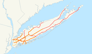
English: This is a map of the rail network currently owned by the Long Island Rail Road. Orange lines are freight-only, and are operated by the New York and Atlantic Railway. Thin black lines have been abandoned. A yellow highlight indicates electrification.
The following GIS data was used:
Deutsch: Karte des Streckennetzes der Long Island Rail Road auf der gleichnamigen Insel.
|
| Dato | 13. desember 2006 (original upload date) |
| Kilde | No machine-readable source provided. Own work assumed (based on copyright claims). |
| Opphavsperson | Ingen maskinlesbar opphavsperson oppgitt. NE2 er antatt opphavsperson, basert på opplysninger om opphavsrett. |
Lisensiering
| Jeg, opphavsrettensholderen til dette verket, frigir dette verket til allmennheten. Dette gjelder på verdensbasis. I enkelte land kan dette være juridisk umulig. I så fall: Jeg gir hvem som helst retten til å bruke dette verket for ethvert formål, uten noen vilkår, med mindre slike vilkår kreves ved lov. |
Filhistorikk
Klikk på et tidspunkt for å vise filen slik den var på det tidspunktet.
| Dato/klokkeslett | Miniatyrbilde | Dimensjoner | Bruker | Kommentar | |
|---|---|---|---|---|---|
| nåværende | 10. apr. 2017 kl. 00:55 | | 512 × 304 (370 KB) | Train2104 | Lower Montauk freight only |
| 23. jan. 2007 kl. 07:11 |  | 1 152 × 684 (583 KB) | NE2 | Changed the orange. | |
| 23. jan. 2007 kl. 07:05 |  | 1 152 × 684 (583 KB) | NE2 | Made the black grayer. | |
| 23. jan. 2007 kl. 07:03 |  | 1 152 × 684 (583 KB) | NE2 | Added a few features. | |
| 13. des. 2006 kl. 12:34 |  | 1 152 × 684 (517 KB) | NE2 | This is a map of the rail network currentl[y owned by the Long Island Rail Road. Orange lines are freight-only, and are operated by the New York and Atlantic Railway. The following GIS data was used: *[http://www.bts.gov/publications/north_american_trans |
Filbruk
Den følgende siden bruker denne filen:
Global filbruk
Følgende andre wikier bruker denne filen:
- Bruk i ceb.wikipedia.org
- Bruk i da.wikipedia.org
- Bruk i de.wikipedia.org
- Bruk i en.wikipedia.org
- Bruk i es.wikipedia.org
- Bruk i et.wikipedia.org
- Bruk i fr.wikipedia.org
- Bruk i he.wikivoyage.org
- Bruk i id.wikipedia.org
- Bruk i it.wikipedia.org
- Bruk i ja.wikipedia.org
- Bruk i ko.wikipedia.org
- Bruk i nl.wikipedia.org
- Bruk i oc.wikipedia.org
- Bruk i pl.wikipedia.org
- Bruk i pt.wikipedia.org
- Bruk i ru.wikipedia.org
- Bruk i simple.wikipedia.org
- Bruk i sv.wikipedia.org
- Bruk i www.wikidata.org
- Bruk i zh.wikipedia.org