
Fil:Arabat arrow.jpg
Størrelse på denne forhåndsvisningen: 800 × 542 piksler. Andre oppløsninger: 320 × 217 piksler | 640 × 434 piksler | 1 024 × 694 piksler | 1 199 × 813 piksler.
Opprinnelig fil (1 199 × 813 piksler, filstørrelse: 87 KB, MIME-type: image/jpeg)
| Denne filen er fra Wikimedia Commons og kan brukes av andre prosjekter. Informasjonen fra filbeskrivelsessiden vises nedenfor. |

|
Dette bildet bør gjenskapes med hjelp av vektorgrafikk som en SVG-fil. Dette har flere fordeler, se Commons:Media for cleanup for mer informasjon. Hvis en SVG-fil med dette bildet er tilgjengelig, vennligst last den opp. Etter opplasting erstatt denne malen med {{vector version available|nytt bilde.svg}}.
|


Beskrivelse
| Beskrivelse |
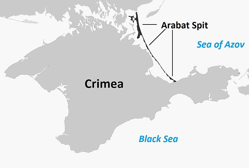
English: Map of the entire Crimea highlighting the Arabat Arrow (or Arabat Spit), the body of land separating the Syvash from the Sea of Azov |
| Dato | |
| Kilde |
This file was derived from: Sevastopol location map.svg |
| Opphavsperson | User:Herostratus |
Lisensiering
| Dette verket har blitt frigitt til allmennheten av opphavspersonen Herostratus at engelsk Wikipedia. Dette gjelder på verdensbasis. I enkelte land kan dette være juridisk umulig. I så fall: Herostratus gir hvem som helst retten til å bruke dette verket for ethvert formål, uten noen vilkår, med mindre slike vilkår kreves ved lov. |
Orginal opplastningslogg
Transferred from en.wikipedia to Commons using For the Common Good.
The original description page was here. All following user names refer to en.wikipedia.
| Dato/klokkeslett | Dimensjoner | Bruker | Kommentar |
|---|---|---|---|
| 16:30, 5 October 2014 | 1,199 × 813 (87,232 bytes) | w:en:Herostratus (diskusjon | bidrag) | let's try this one -- improvement? |
| 16:19, 5 October 2014 | 960 × 651 (70,458 bytes) | w:en:Herostratus (diskusjon | bidrag) | ==Summary== {{Information |Description = Map of the entire Crimea highlighting the Arabat Arrow (or Arabat Spit), the body of land separating the Syvash from the Sea of Azov |Source = https://commons.wikimedia.org/wiki/File:Sevastopol_location_map.svg... |
Filhistorikk
Klikk på et tidspunkt for å vise filen slik den var på det tidspunktet.
| Dato/klokkeslett | Miniatyrbilde | Dimensjoner | Bruker | Kommentar | |
|---|---|---|---|---|---|
| nåværende | 17. des. 2018 kl. 13:39 | 1 199 × 813 (87 KB) | Bogomolov.PL | according common English naming | |
| 21. jun. 2016 kl. 09:22 | 1 199 × 813 (85 KB) | Kelly | Transferred from en.wikipedia: see original upload log above | ||
| 21. jun. 2016 kl. 09:22 | 960 × 651 (69 KB) | Kelly | Old revision as of 16:19, 5 October 2014: see original upload log above |
Filbruk
Den følgende siden bruker denne filen:
Global filbruk
Følgende andre wikier bruker denne filen:
- Bruk i ca.wikipedia.org
- Bruk i ceb.wikipedia.org
- Bruk i cs.wikipedia.org
- Bruk i da.wikipedia.org
- Bruk i en.wikipedia.org
- Bruk i es.wikipedia.org
- Bruk i fi.wikipedia.org
- Bruk i hr.wikipedia.org
- Bruk i ja.wikipedia.org
- Bruk i nl.wikipedia.org
- Bruk i pt.wikipedia.org
- Bruk i sv.wikipedia.org
- Bruk i tr.wikipedia.org
- Bruk i www.wikidata.org