Saint-Gilles (Manche)
| Saint-Gilles | |||
|---|---|---|---|
 | |||
| Land | |||
| Region | Normandie | ||
| Departement | |||
| Arrondissement | Saint-Lô | ||
| Kanton | Marigny | ||
| Status | Kommune | ||
| Postnummer | 50180 | ||
| Areal | 7,84 km²[1] | ||
| Befolkning | 985[2] (2021) | ||
| Bef.tetthet | 125,64 innb./km² | ||
| Høyder – Høyeste – Laveste | 104 12 | ||
| Høyde o.h. | 101 meter | ||
| Politikk | |||
| Maire | Jean-Luc Lerouxel (2014–2020) | ||
 Saint-Gilles 49°06′17″N 1°10′32″V | |||
Saint-Gilles är en kommune i departementet Manche i regionen Normandie nord i Frankrike. Kommunen ligger i kantonen Marigny som tilhører arrondissementet Saint-Lô. I 2010 hadde Saint-Gilles 905 innbyggere.[3]
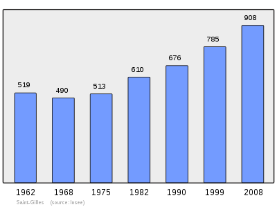
Befolkningsutvikling[rediger | rediger kilde]
Antall innbyggere i kommunen Saint-Gilles
 |
Referanser[rediger | rediger kilde]
- ^ répertoire géographique des communes, Institut national de l'information géographique et forestière, Wikidata Q20894925, https://geoservices.ign.fr/documentation/diffusion/index.html
- ^ (på fr) Populations légales 2021, INSEE, 28. desember 2023, Wikidata Q124036546, https://www.insee.fr/fr/statistiques/7728826
- ^ «Populations légales 2010 pour les départements et les collectivités d’outre-mer». www.insee.fr. Institut national de la statistique et des études économiques (Insee). desember 2012.
- ^ Chiffres clés - Évolution et structure de la population
Eksterne lenker[rediger | rediger kilde]
- (en) Saint-Gilles (Manche) – kategori av bilder, video eller lyd på Commons
- Kommunedata INSEE

|
Hébécrevon, Le Mesnil-Amey (NV) |
Hébécrevon (N) | Agneaux (NØ) | 
|
| Canisy (V) | Saint-Lô (Ø) | |||
| Canisy (SV) | Canisy, Saint-Ébremond-de-Bonfossé (S) | Saint-Ébremond-de-Bonfossé (SØ) |


