
Fil:Wilderness road en.png

Størrelse på denne forhåndsvisningen: 800 × 508 piksler. Andre oppløsninger: 320 × 203 piksler | 640 × 406 piksler | 1 024 × 650 piksler | 1 254 × 796 piksler.
Opprinnelig fil (1 254 × 796 piksler, filstørrelse: 1,74 MB, MIME-type: image/png)
| Denne filen er fra Wikimedia Commons og kan brukes av andre prosjekter. Informasjonen fra filbeskrivelsessiden vises nedenfor. |
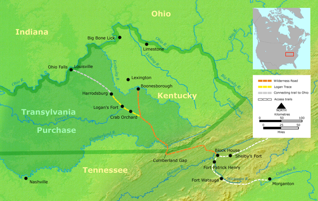
- Description: Course of the Wilderness Road in Kentucky by 2013. Darker green outlines represent the later boundaries of Kentucky, while green shading represents the Transylvania Purchase.
- Source: Own work by Nikater, submitted to the public domain. Background map courtesy of Demis, www.demis.nl.
- Uploader: User:Nikater
- date;14 April 2000
- Other Versions: German Image:Wilderness road_de.png
- License status:
This image is in the public domain because it came from the site https://www.demis.nl/products/web-map-server/examples/ and was released by the copyright holder. Permission is granted to copy, distribute and/or modify this map since it is based on free of copyright images from: www.demis.nl. See also approval email on de.wp and its clarification.
|
| This work has been released into the public domain by its copyright holder, www.demis.nl. This applies worldwide. I enkelte land kan dette være juridisk umulig. I så fall: www.demis.nl gir hvem som helst retten til å bruke dette verket for ethvert formål, uten noen vilkår, med mindre slike vilkår kreves ved lov.
|

|
Dette bildet bør gjenskapes med hjelp av vektorgrafikk som en SVG-fil. Dette har flere fordeler, se Commons:Media for cleanup for mer informasjon. Hvis en SVG-fil med dette bildet er tilgjengelig, vennligst last den opp. Etter opplasting erstatt denne malen med {{vector version available|nytt bilde.svg}}.
|
Filhistorikk
Klikk på et tidspunkt for å vise filen slik den var på det tidspunktet.
| Dato/klokkeslett | Miniatyrbilde | Dimensjoner | Bruker | Kommentar | |
|---|---|---|---|---|---|
| nåværende | 23. mar. 2007 kl. 21:16 | | 1 254 × 796 (1,74 MB) | Nikater | * Description: Course of the Wilderness Road in Kentucky by 1785 * Source: Own work by Nikater, submitted to the public domain. Background map courtesy of Demis, www.demis.nl. * Uploader: User:Nikater * Date: 23 Mar 2007 * Other Versions: German: Imag |
| 21. mar. 2007 kl. 15:24 |  | 1 254 × 796 (1,74 MB) | Nikater | * Description: Course of the Wilderness Road in Kentucky by 1785 * Source: Own work by Nikater, submitted to the public domain. Background map courtesy of Demis, www.demis.nl. * Uploader: User:Nikater * Date: 21 Mar 2007 * Other Versions: German: Imag | |
| 18. mar. 2007 kl. 19:17 |  | 1 254 × 796 (1,74 MB) | Nikater | * Description: Course of the Wilderness Road in Kentucky by 1785 * Source: Own work by Nikater, submitted to the public domain. Background map courtesy of Demis, www.demis.nl. * Uploader: User:Nikater * Date: 18 Mar 2007 * Other Versions: German: Imag | |
| 17. mar. 2007 kl. 14:13 |  | 1 255 × 760 (1,63 MB) | Nikater | * Description: Course of the Wilderness Road in Kentucky by 1785 * Source: Own work by Nikater, submitted to the public domain. Background map courtesy of Demis, www.demis.nl. * Uploader: User:Nikater * Date: 17 Mar 2007 * Other Versions: German [[Ima |
Filbruk
De følgende 3 sidene bruker denne filen:
Global filbruk
Følgende andre wikier bruker denne filen:
- Bruk i ar.wikipedia.org
- Bruk i ca.wikipedia.org
- Bruk i da.wikipedia.org
- Bruk i de.wikipedia.org
- Bruk i en.wikipedia.org
- Henderson, Kentucky
- Elizabethton, Tennessee
- Clarksville, Tennessee
- American frontier
- Transylvania Colony
- Boonesborough, Kentucky
- Wilderness Road
- Cumberland Gap
- Big Bone, Kentucky
- Richard Henderson (jurist)
- Logan Trace
- Sycamore Shoals
- Cherokee–American wars
- User talk:Kevin1776/Archive 2
- John W. Frazer
- User:Brendan.Hunstad/draft on Cumberland Gap
- User:Drdpw/sandbox2
- Bruk i es.wikipedia.org
- Bruk i fr.wikipedia.org
- Bruk i it.wikipedia.org
- Bruk i ja.wikipedia.org
- Bruk i nl.wikipedia.org
- Bruk i pl.wikipedia.org
- Bruk i ru.wikipedia.org