
Fil:Uspaintedrelief.png

Størrelse på denne forhåndsvisningen: 800 × 578 piksler. Andre oppløsninger: 320 × 231 piksler | 640 × 463 piksler | 1 024 × 740 piksler | 1 280 × 925 piksler | 2 336 × 1 689 piksler.
Opprinnelig fil (2 336 × 1 689 piksler, filstørrelse: 3,46 MB, MIME-type: image/png)
| Denne filen er fra Wikimedia Commons og kan brukes av andre prosjekter. Informasjonen fra filbeskrivelsessiden vises nedenfor. |
Beskrivelse
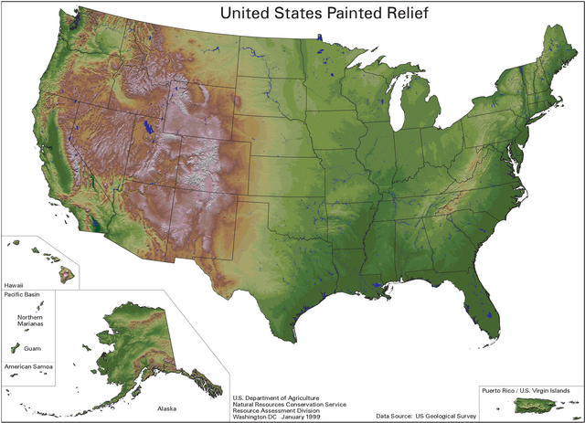
English: A painted relief map of the United States, showing shaded topographic information.
- Using U.S. Geological Survey data and published by the Natural Resources Conservation Service.
- The color scheme for the shading was done by Karl Musser.
Lisensiering
This work is in the public domain in the United States because it is a work prepared by an officer or employee of the United States Government as part of that person’s official duties under the terms of Title 17, Chapter 1, Section 105 of the US Code.
Note: This only applies to original works of the Federal Government and not to the work of any individual U.S. state, territory, commonwealth, county, municipality, or any other subdivision. This template also does not apply to postage stamp designs published by the United States Postal Service since 1978. (See § 313.6(C)(1) of Compendium of U.S. Copyright Office Practices). It also does not apply to certain US coins; see The US Mint Terms of Use.
|
 | |
| Denne filen har blitt identifisert til å være fri for kjente restriksjoner under lov om opphavsrett, inkludert alle relaterte og nærstående rettigheter. | ||
Filhistorikk
Klikk på et tidspunkt for å vise filen slik den var på det tidspunktet.
| Dato/klokkeslett | Miniatyrbilde | Dimensjoner | Bruker | Kommentar | |
|---|---|---|---|---|---|
| nåværende | 3. jan. 2007 kl. 17:37 | | 2 336 × 1 689 (3,46 MB) | Kmusser | This is a painted relief map of the United States using U.S. Geological Survey data and published by the Natural Resources Conservation Service. The color scheme for the shading was done by Karl Musser. |
Filbruk
Den følgende siden bruker denne filen:
Global filbruk
Følgende andre wikier bruker denne filen:
- Bruk i arz.wikipedia.org
- Bruk i bg.wikipedia.org
- Bruk i en.wikipedia.org
- Bruk i incubator.wikimedia.org
- Bruk i io.wikipedia.org
- Bruk i ku.wikipedia.org
- Bruk i or.wikipedia.org
- Bruk i pt.wikipedia.org
- Bruk i tr.wikipedia.org
- Bruk i tum.wikipedia.org
- Bruk i zh.wikipedia.org