
Fil:Pluto-map-hs-2010-06-d270.jpg

Størrelse på denne forhåndsvisningen: 600 × 600 piksler. Andre oppløsninger: 240 × 240 piksler | 480 × 480 piksler | 768 × 768 piksler | 1 200 × 1 200 piksler.
Opprinnelig fil (1 200 × 1 200 piksler, filstørrelse: 196 KB, MIME-type: image/jpeg)
| Denne filen er fra Wikimedia Commons og kan brukes av andre prosjekter. Informasjonen fra filbeskrivelsessiden vises nedenfor. |
| Beskrivelse |
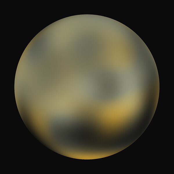
English: A best-fit color image/map of Pluto generated with the Hubble Space Telescope and advanced computers. It is unknown if the brightness differences are mountains, craters, or polar caps. |
|||||
| Dato | ||||||
| Kilde | http://hubblesite.org/newscenter/archive/releases/2010/06/image/d/ | |||||
| Opphavsperson | NASA, ESA, and Marc W. Buie (Southwest Research Institute) | |||||
| Tillatelse (Gjenbruk av denne filen) |
Any web pages, publications, or any other published use of these maps should provide a legible credit line consistent with the medium that states: "Images are courtesy of Marc W. Buie, Southwest Research Institute"
|
|||||
| Andre versjoner | Pluto-map-hs-2010-06-b90.jpg, Pluto-map-hs-2010-06-c180.jpg |

Filhistorikk
Klikk på et tidspunkt for å vise filen slik den var på det tidspunktet.
| Dato/klokkeslett | Miniatyrbilde | Dimensjoner | Bruker | Kommentar | |
|---|---|---|---|---|---|
| nåværende | 5. feb. 2010 kl. 10:46 | | 1 200 × 1 200 (196 KB) | Kwamikagami | {{Information |Description={{en|1=A best-fit color image/map of Pluto generated with the Hubble Space Telescope and advanced computers. It is unknown if the brightness differences are mountains, craters, or polar caps.}} |Source=http://hubblesite.org/news |
Filbruk
Det er ingen sider som bruker denne filen.
Global filbruk
Følgende andre wikier bruker denne filen:
- Bruk i en.wikipedia.org