
Fil:PeloponnesosMap.png

Opprinnelig fil (330 × 653 piksler, filstørrelse: 67 KB, MIME-type: image/png)
| Denne filen er fra Wikimedia Commons og kan brukes av andre prosjekter. Informasjonen fra filbeskrivelsessiden vises nedenfor. |
This image was copied from wikipedia:en. The original description was:
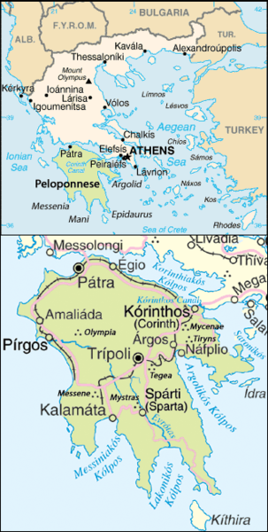
Map of the Peloponnesos.
Adapted from http://www.un.org/Depts/Cartographic/map/profile/greece.pdf
| This image is a work of a Central Intelligence Agency employee, taken or made as part of that person's official duties. As a Work of the United States Government, this image or media is in the public domain in the United States.
|

|
| This image is a map derived from a United Nations map.
Unless stated otherwise, UN maps are to be considered in the public domain. This applies worldwide. UN maps are, in principle, open source material and you can use them in your work or for making your own map. UN requests however that you delete the UN name, logo and reference number upon any modification to the map. Content of your map will be your responsibility. You can state in your publication, if you wish, something like: based on UN map … (map name, map number, revision number and date). See: Geospatial Information Section. And: Geospatial, location data for a better world. |
 |
| date/time | username | edit summary |
|---|---|---|
| 22:08, 25 June 2005 | ChrisO | |
| 22:07, 25 June 2005 | ChrisO | |
| 22:03, 25 June 2005 | ChrisO | (Map of the <a href="/wiki/Peloponnesos" title="Peloponnesos">Peloponnesos</a>. Adapted from www.un.org/Depts/Cartographic/map/profile/greece.pdf {{PD-USGov-CIA}} {{UN-map}}) |
Filhistorikk
Klikk på et tidspunkt for å vise filen slik den var på det tidspunktet.
| Dato/klokkeslett | Miniatyrbilde | Dimensjoner | Bruker | Kommentar | |
|---|---|---|---|---|---|
| nåværende | 26. okt. 2017 kl. 00:26 | | 330 × 653 (67 KB) | Peritios | Reverted to version as of 23:41, 24 October 2017 (UTC) |
| 25. okt. 2017 kl. 09:58 |  | 330 × 653 (152 KB) | MacedonianBoy | Reverted to version as of 08:59, 20 October 2013 (UTC) | |
| 25. okt. 2017 kl. 01:41 |  | 330 × 653 (67 KB) | Peritios | Reverted to version as of 20:28, 8 October 2005 (UTC) | |
| 3. aug. 2014 kl. 22:44 |  | 328 × 650 (51 KB) | Ras67 | cropped | |
| 20. okt. 2013 kl. 10:59 |  | 330 × 653 (152 KB) | MacedonianBoy | name change | |
| 8. okt. 2005 kl. 22:28 |  | 330 × 653 (67 KB) | ChongDae | This image was copied from wikipedia:en. The original description was: Map of the Peloponnesos. Adapted from http://www.un.org/Depts/Cartographic/map/profile/greece.pdf {{PD-USGov-CIA}} {{UN map}} {| border="1" ! date/time || username || edit sum |
Filbruk
Den følgende siden bruker denne filen:
Global filbruk
Følgende andre wikier bruker denne filen:
- Bruk i af.wikipedia.org
- Bruk i ar.wikipedia.org
- Bruk i br.wikipedia.org
- Bruk i cs.wikipedia.org
- Bruk i en.wikipedia.org
- Bruk i fa.wikipedia.org
- Bruk i fo.wikipedia.org
- Bruk i hi.wikipedia.org
- Bruk i hu.wikipedia.org
- Bruk i incubator.wikimedia.org
- Bruk i ka.wikipedia.org
- Bruk i ko.wikipedia.org
- Bruk i lt.wikipedia.org
- Bruk i nn.wikipedia.org
- Bruk i ro.wikipedia.org
- Bruk i rue.wikipedia.org
- Bruk i sh.wikipedia.org
- Bruk i sl.wikipedia.org
- Bruk i sr.wikipedia.org
- Bruk i tr.wikipedia.org