
Fil:Pacific Ring of Fire.png
Størrelse på denne forhåndsvisningen: 800 × 593 piksler. Andre oppløsninger: 320 × 237 piksler | 640 × 475 piksler | 1 024 × 760 piksler | 1 046 × 776 piksler.
Opprinnelig fil (1 046 × 776 piksler, filstørrelse: 66 KB, MIME-type: image/png)
| Denne filen er fra Wikimedia Commons og kan brukes av andre prosjekter. Informasjonen fra filbeskrivelsessiden vises nedenfor. |

|
En vektorversjon av dette bildet (SVG) er tilgjengelig.
Det bør brukes i stedet for punktgrafikkbildet når det er fordelaktig. File:Pacific Ring of Fire.png → File:Pacific Ring of Fire.svg
For mer informasjon om vektorgrafikk les Commons transition to SVG. Se også information about MediaWiki's support of SVG images. |
 |
Beskrivelse
| Beskrivelse |
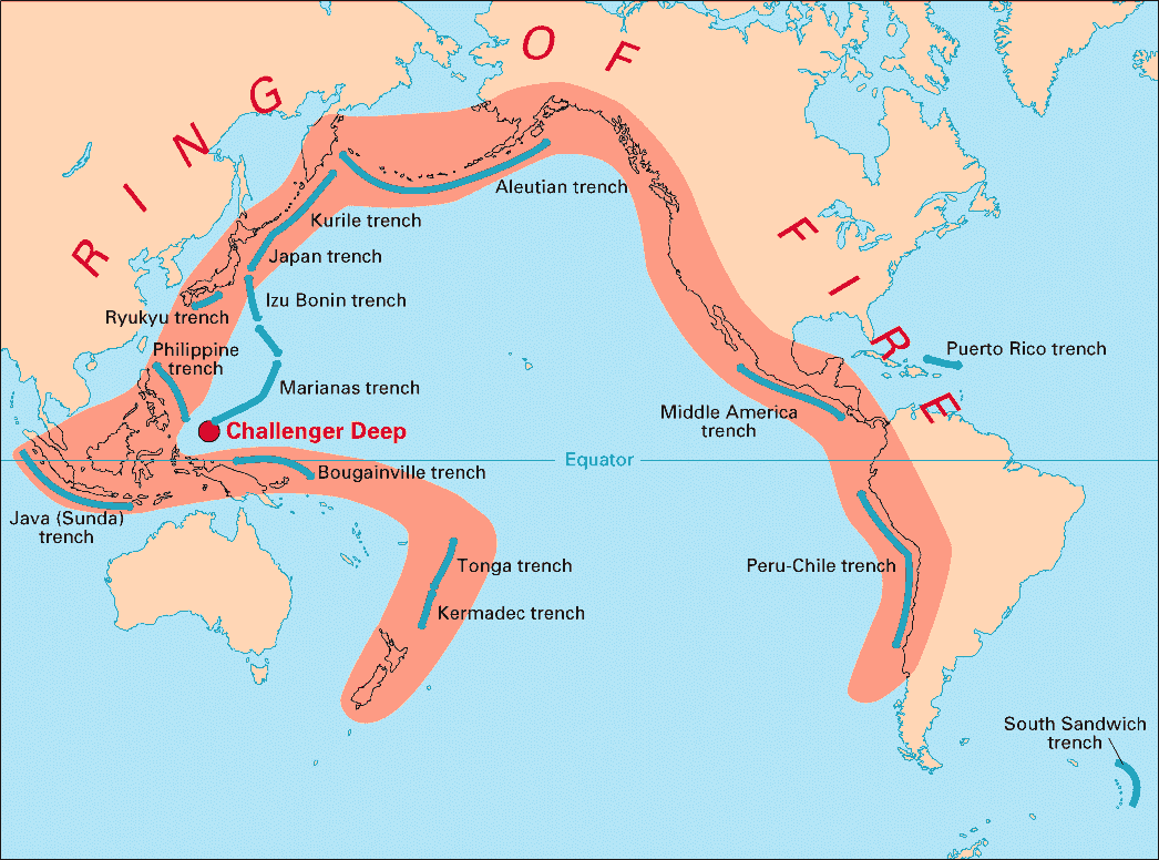
English: Volcanic arcs and oceanic trenches partly encircling the Pacific Basin form the so-called Pacific Ring of fire, a zone of frequent earthquakes and volcanic eruptions. The trenches are shown in blue-green. The volcanic island arcs, although not labelled, are parallel to, and always landward of, the trenches. For example, the island arc associated with the Aleutian Trench is represented by the long chain of volcanoes that make up the Aleutian Islands. |
| Dato | |
| Kilde | http://pubs.usgs.gov/publications/text/fire.html |
| Opphavsperson | USGS |
Lisensiering
This image is in the public domain in the United States because it only contains materials that originally came from the United States Geological Survey, an agency of the United States Department of the Interior. For more information, see the official USGS copyright policy.
|
Filhistorikk
Klikk på et tidspunkt for å vise filen slik den var på det tidspunktet.
| Dato/klokkeslett | Miniatyrbilde | Dimensjoner | Bruker | Kommentar | |
|---|---|---|---|---|---|
| nåværende | 28. des. 2004 kl. 05:28 | | 1 046 × 776 (66 KB) | Ævar Arnfjörð Bjarmason | Deeper colours |
| 28. des. 2004 kl. 05:26 |  | 1 046 × 776 (156 KB) | Ævar Arnfjörð Bjarmason |
Filbruk
De følgende 2 sidene bruker denne filen:
Global filbruk
Følgende andre wikier bruker denne filen:
- Bruk i als.wikipedia.org
- Bruk i ar.wikipedia.org
- Bruk i ary.wikipedia.org
- Bruk i bs.wikipedia.org
- Bruk i ca.wikipedia.org
- Bruk i da.wikipedia.org
- Bruk i dsb.wikipedia.org
- Bruk i en.wikipedia.org
- Bruk i en.wikibooks.org
- Bruk i eo.wikipedia.org
- Bruk i eu.wikipedia.org
- Bruk i fr.wikipedia.org
- Bruk i gl.wikipedia.org
- Bruk i hr.wikipedia.org
- Bruk i hsb.wikipedia.org
- Bruk i id.wikipedia.org
- Bruk i it.wikipedia.org
- Bruk i ko.wikipedia.org
- Bruk i ko.wikinews.org
- Bruk i lt.wikipedia.org
- Bruk i lv.wikipedia.org
- Bruk i mg.wikipedia.org
- Bruk i ms.wikipedia.org
- Bruk i nia.wikipedia.org
- Bruk i nl.wikipedia.org
- Bruk i nn.wikipedia.org
- Bruk i pap.wikipedia.org
- Bruk i pnb.wikipedia.org
- Bruk i ro.wikipedia.org
- Bruk i simple.wikipedia.org
- Bruk i sk.wikipedia.org
- Bruk i sl.wikipedia.org
- Bruk i sr.wikipedia.org
- Bruk i su.wikipedia.org
- Bruk i sv.wikipedia.org
Vis mer global bruk av denne filen.