
Fil:NorthamptonshireWellingborough.png
Ingen høyere oppløsning tilgjengelig.
NorthamptonshireWellingborough.png (200 × 222 piksler, filstørrelse: 14 KB, MIME-type: image/png)
| Denne filen er fra Wikimedia Commons og kan brukes av andre prosjekter. Informasjonen fra filbeskrivelsessiden vises nedenfor. |
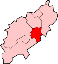
Wellingborough in Northamptonshire
Created by en:User:Morwen

|
Det tillates at dette dokumentet kopieres, distribueres og/eller modifiseres under retningslinjene som beskrevet i GNU fri dokumentasjonslisens, versjon 1.2 eller senere utgave utgitt av Free Software Foundation; med alle seksjoner, uten noen forsidetekster og baksidetekster. En kopi av lisensen er inkludert i avsnittet GNU Free Documentation License. |
| Denne filen er lisensiert under lisensen Creative Commons Navngivelse-DelPåSammeVilkår 3.0 Unported | ||
| ||
| Dette lisensmerket ble lagt til filen som del av lisensoppdateringen av GFDL. |
Filhistorikk
Klikk på et tidspunkt for å vise filen slik den var på det tidspunktet.
| Dato/klokkeslett | Miniatyrbilde | Dimensjoner | Bruker | Kommentar | |
|---|---|---|---|---|---|
| nåværende | 24. mai 2006 kl. 23:05 | | 200 × 222 (14 KB) | Nichtbesserwisser | Wellingborough in Northamptonshire Created by en:User:Morwen {{GFDL}} Category:Maps of districts in East Midlands |
Filbruk
Den følgende siden bruker denne filen:
Global filbruk
Følgende andre wikier bruker denne filen:
- Bruk i bg.wikipedia.org
- Bruk i de.wikipedia.org
- Bruk i en.wikipedia.org
- Sywell Aerodrome
- Sywell
- Wellingborough
- Borough of Wellingborough
- Wollaston, Northamptonshire
- Grendon, Northamptonshire
- Wellingborough School
- Easton Maudit
- Wilby, Northamptonshire
- Isham
- Wellingborough (UK Parliament constituency)
- Mears Ashby
- Finedon
- Wellingborough railway station
- Ecton, Northamptonshire
- Great Doddington
- Strixton
- A509 road
- Earls Barton
- Bozeat
- Wellingborough Whitworth F.C.
- Wellingborough Town F.C.
- Irchester
- Redhill Grange
- Orlingbury
- Great Harrowden
- Little Harrowden
- Tresham College of Further and Higher Education
- The Castle Theatre, Wellingborough
- Hardwick, Northamptonshire
- Template:BC Wellingborough
- Bruk i fa.wikipedia.org
- Bruk i it.wikipedia.org
- Bruk i nl.wikipedia.org
- Bruk i ro.wikipedia.org