
Fil:Morgenthau Plan map.svg

Størrelse for denne PNG-forhåndsvisningen av denne SVG-filen: 671 × 442 piksler Andre oppløsninger: 320 × 211 piksler | 640 × 422 piksler | 1 024 × 675 piksler | 1 280 × 843 piksler | 2 560 × 1 686 piksler.
Opprinnelig fil (SVG-fil, standardstørrelse 671 × 442 piksler, filstørrelse: 132 KB)
| Denne filen er fra Wikimedia Commons og kan brukes av andre prosjekter. Informasjonen fra filbeskrivelsessiden vises nedenfor. |
Beskrivelse
| Beskrivelse |
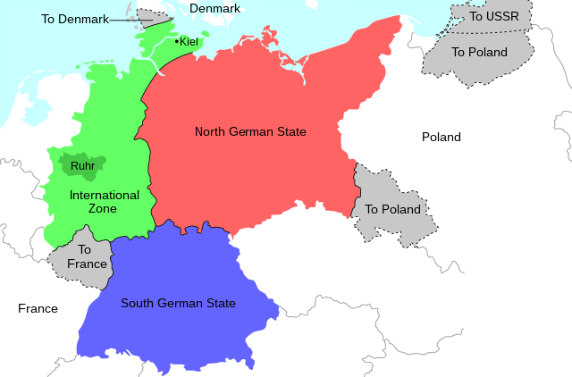
English: Map of the 1944 Morgenthau Plan, which would have seen Germany totally demilitarised and divided into three areas: a Northern state, a Southern state, and a de-industrialised International Zone in the west, administered by "an international security organization, to be established by the United Nations". The International Zone included the Ruhr area, regarded as Germany's industrial heartland, and the important naval port of Kiel. The intention was to prevent Germany from ever again being able to develop military industry or wage war. In addition, the Saar region and surrounding area was to be ceded to France; most of Silesia and southern East Prussia to Poland; northern East Prussia to the USSR; and northern Schleswig to Denmark. |
| Dato | |
| Kilde | Eget verk |
| Opphavsperson | Erinthecute |
| SVG utvikling | Denne vektorgrafikken ble laget med Inkscape. |
Lisensiering
Jeg, rettighetsinnehaver av dette arbeidet, publiserer det herved under følgende lisens:
Denne filen er lisensiert under lisensen Creative Commons Navngivelse-DelPåSammeVilkår 4.0 Internasjonal.
- Du står fritt:
- til å dele – til å kopiere, distribuere og overføre verket
- til å blande – til å endre verket
- Under de følgende betingelsene:
- navngivelse – Du må kreditere verket på passende vis, lenke til lisensen og indikere hvorvidt det har blitt gjort endringer. Du kan gjøre det på enhver rimelig måte, men ikke på en måte som antyder at lisensgiveren støtter deg eller din bruk av verket.
- del på samme vilkår – Dersom du remikser, omarbeider eller på annen måte bygger på dette verket, må du kun distribuere resultatet under den samme eller en samsvarende lisens som denne.
Filhistorikk
Klikk på et tidspunkt for å vise filen slik den var på det tidspunktet.
| Dato/klokkeslett | Miniatyrbilde | Dimensjoner | Bruker | Kommentar | |
|---|---|---|---|---|---|
| nåværende | 31. jul. 2020 kl. 07:36 | | 671 × 442 (132 KB) | Erinthecute | Fixed background. |
| 31. jul. 2020 kl. 07:32 |  | 671 × 442 (131 KB) | Erinthecute | Added highlights of the Ruhr area and Kiel, which were important elements of Moregnthau's plan for deindustrialisation and demilitarisation. | |
| 31. jul. 2020 kl. 05:48 |  | 671 × 442 (128 KB) | Erinthecute | Uploaded own work with UploadWizard |
Filbruk
De følgende 2 sidene bruker denne filen:
Global filbruk
Følgende andre wikier bruker denne filen:
- Bruk i ar.wikipedia.org
- Bruk i el.wikipedia.org
- Bruk i en.wikipedia.org
- Bruk i he.wikipedia.org
- Bruk i id.wikipedia.org
- Bruk i mk.wikipedia.org
- Bruk i pl.wikipedia.org
- Bruk i th.wikipedia.org
- Bruk i tr.wikipedia.org
- Bruk i vi.wikipedia.org