
Fil:Map indicating Foxe Basin, Nunavut, Canada.png
Ingen høyere oppløsning tilgjengelig.
Map_indicating_Foxe_Basin,_Nunavut,_Canada.png (360 × 330 piksler, filstørrelse: 47 KB, MIME-type: image/png)
| Denne filen er fra Wikimedia Commons og kan brukes av andre prosjekter. Informasjonen fra filbeskrivelsessiden vises nedenfor. |
Beskrivelse
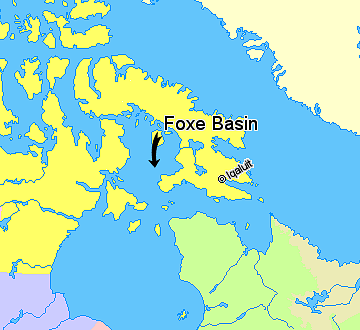
Map indicating Foxe Basin, Nunavut, Canada.
Nunavut
Greenland
Quebec
Newfoundland and Labrador
Manitoba
© Her Majesty the Queen in Right of Canada, Department of Natural Resources. All rights reserved.
Licence Agreement
Lisensiering

|
The copyright holder of this work allows anyone to use it for any purpose including unrestricted redistribution, commercial use, and modification.
Usage notes:
|
Filhistorikk
Klikk på et tidspunkt for å vise filen slik den var på det tidspunktet.
| Dato/klokkeslett | Miniatyrbilde | Dimensjoner | Bruker | Kommentar | |
|---|---|---|---|---|---|
| nåværende | 21. mar. 2006 kl. 16:31 | | 360 × 330 (47 KB) | David Kernow~commonswiki | == Summary == Map indicating Foxe Basin, Nunavut, Canada. {{legend|#ffff66|Nunavut}} {{legend|#ffffcc|Greenland}} {{legend|#d5fe94|Quebec}} {{legend|#ecebb6|Newfoundland and Labrador}} {{legend|#ccccff|Manitoba}} {{legend|#ffcccc|Ontario |
Filbruk
Den følgende siden bruker denne filen:
Global filbruk
Følgende andre wikier bruker denne filen:
- Bruk i ar.wikipedia.org
- Bruk i bs.wikipedia.org
- Bruk i ca.wikipedia.org
- Bruk i ceb.wikipedia.org
- Bruk i da.wikipedia.org
- Bruk i de.wikipedia.org
- Bruk i en.wikipedia.org
- Bruk i es.wikipedia.org
- Bruk i fi.wikipedia.org
- Bruk i fr.wikipedia.org
- Bruk i hr.wikipedia.org
- Bruk i hu.wikipedia.org
- Bruk i is.wikipedia.org
- Bruk i ja.wikipedia.org
- Bruk i nl.wikipedia.org
- Bruk i nn.wikipedia.org
- Bruk i pt.wikipedia.org
- Bruk i ro.wikipedia.org
- Bruk i sh.wikipedia.org
- Bruk i sr.wikipedia.org
- Bruk i sv.wikipedia.org
- Bruk i www.wikidata.org
- Bruk i zh-min-nan.wikipedia.org
- Bruk i zh.wikipedia.org