
Fil:Kansaspacificgrants.jpg
Størrelse på denne forhåndsvisningen: 800 × 527 piksler. Andre oppløsninger: 320 × 211 piksler | 640 × 422 piksler | 1 024 × 675 piksler | 1 280 × 844 piksler | 2 560 × 1 688 piksler | 5 304 × 3 497 piksler.
Opprinnelig fil (5 304 × 3 497 piksler, filstørrelse: 2,71 MB, MIME-type: image/jpeg)
| Denne filen er fra Wikimedia Commons og kan brukes av andre prosjekter. Informasjonen fra filbeskrivelsessiden vises nedenfor. |
Beskrivelse
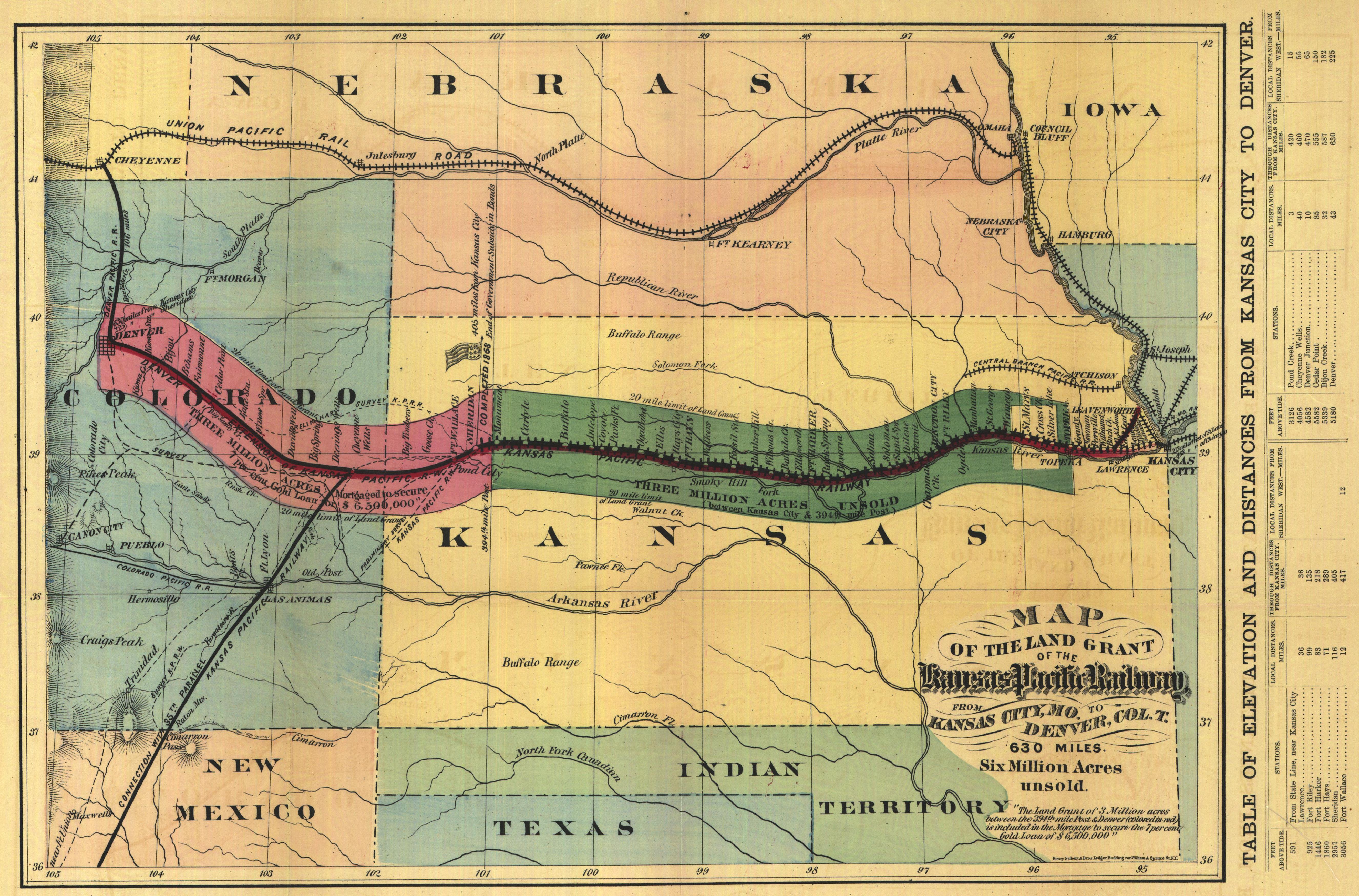
- Historic map of the proposed Kansas Pacific Railway lines in the Western U.S.
- Proposed route for the First Transcontinental Railroad.
- The map is entitled Map of the Land Grant of the Kansas Pacific Railway, from Kansas City, Mo. to Denver Col. T.. It was made in 1869 by Henry Seibert & Bros. The original map is 28 x 40 cm. In addition to the rail line, the map shows Native American habitation and bison ranges. The line between Kansas City (east) and Denver (west) is separated into the two sections (the western extension to Colorado was built in 1879, several years after the eastern section). The coloration indicates the extent of the land grants on either side of the rail line.
- Credits
source: Digitized Kansas maps from the University of Wichita
This media file is in the public domain in the United States. This applies to U.S. works where the copyright has expired, often because its first publication occurred prior to January 1, 1929, and if not then due to lack of notice or renewal. See this page for further explanation.
|
 | |
 |
This image might not be in the public domain outside of the United States; this especially applies in the countries and areas that do not apply the rule of the shorter term for US works, such as Canada, Mainland China (not Hong Kong or Macao), Germany, Mexico, and Switzerland. The creator and year of publication are essential information and must be provided. See Wikipedia:Public domain and Wikipedia:Copyrights for more details.
|
Filhistorikk
Klikk på et tidspunkt for å vise filen slik den var på det tidspunktet.
| Dato/klokkeslett | Miniatyrbilde | Dimensjoner | Bruker | Kommentar | |
|---|---|---|---|---|---|
| nåværende | 22. jul. 2013 kl. 17:51 | | 5 304 × 3 497 (2,71 MB) | Liesel | greater version |
| 13. mar. 2005 kl. 10:55 |  | 640 × 438 (70 KB) | Decumanus~commonswiki | Historic map of the Kansas Pacific Railway lines in the western U.S. |
Filbruk
Den følgende siden bruker denne filen:
Global filbruk
Følgende andre wikier bruker denne filen:
- Bruk i de.wikipedia.org
- Bruk i en.wikipedia.org
- Bruk i es.wikipedia.org
- Bruk i fi.wikipedia.org
- Bruk i fr.wikipedia.org
- Bruk i hu.wikipedia.org
- Bruk i ja.wikipedia.org
- Bruk i simple.wikipedia.org
- Bruk i www.wikidata.org