
Fil:Gulf Coast Snow 2010-02-13.jpg

Størrelse på denne forhåndsvisningen: 600 × 600 piksler. Andre oppløsninger: 240 × 240 piksler | 480 × 480 piksler | 720 × 720 piksler.
Opprinnelig fil (720 × 720 piksler, filstørrelse: 646 KB, MIME-type: image/jpeg)
| Denne filen er fra Wikimedia Commons og kan brukes av andre prosjekter. Informasjonen fra filbeskrivelsessiden vises nedenfor. |
Beskrivelse
| Beskrivelse |
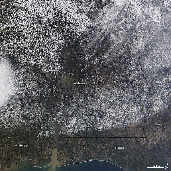
English: A swath of snow covered parts of the Deep South on the morning of February 13, 2010. A storm moved from Texas across the southern United States to the Atlantic Ocean on February 12-13. By the time the Moderate Resolution Imaging Spectroradiometer (MODIS) on NASA’s Terra satellite passed over at 12:10 p.m., Eastern Time, the clouds over Alabama had cleared enough to reveal a strip of snow in the storm’s path. As much as six to fifteen inches of snow fell in the South, reported CNN. |
| Dato | |
| Kilde | http://earthobservatory.nasa.gov/NaturalHazards/view.php?id=42683&src=nha |
| Opphavsperson | NASA |
| Andre versjoner |
|

Lisensiering
| This file is in the public domain in the United States because it was solely created by NASA. NASA copyright policy states that "NASA material is not protected by copyright unless noted". (See Template:PD-USGov, NASA copyright policy page or JPL Image Use Policy.) | ||
 |
Warnings:
|
Filhistorikk
Klikk på et tidspunkt for å vise filen slik den var på det tidspunktet.
| Dato/klokkeslett | Miniatyrbilde | Dimensjoner | Bruker | Kommentar | |
|---|---|---|---|---|---|
| nåværende | 15. feb. 2010 kl. 22:15 | | 720 × 720 (646 KB) | Captain-tucker | {{Information |Description={{en|A swath of snow covered parts of the Deep South on the morning of February 13, 2010. A storm moved from Texas across the southern United States to the Atlantic Ocean on February 12-13. By the time the Moderate Resolution Im |
Filbruk
Den følgende siden bruker denne filen: