
Fil:ElectoralCollege1988-Large.png
Størrelse på denne forhåndsvisningen: 800 × 430 piksler. Andre oppløsninger: 320 × 172 piksler | 640 × 344 piksler | 1 182 × 635 piksler.
Opprinnelig fil (1 182 × 635 piksler, filstørrelse: 170 KB, MIME-type: image/png)
| Denne filen er fra Wikimedia Commons og kan brukes av andre prosjekter. Informasjonen fra filbeskrivelsessiden vises nedenfor. |
| U.S. presidential election maps from the National Atlas of the United States |
| See also: SVG maps |
| 1789 · 1792 · 1796 · 1800 · 1804 · 1808 · 1812 · 1816 · 1820 · 1824 · 1828 · 1832 · 1836 · 1840 · 1844 · 1848 · 1852 · 1856 · 1860 · 1864 · 1868 · 1872 · 1876 · 1880 · 1884 · 1888 · 1892 · 1896 · 1900 · 1904 · 1908 · 1912 · 1916 · 1920 · 1924 · 1928 · 1932 · 1936 · 1940 · 1944 · 1948 · 1952 · 1956 · 1960 · 1964 · 1968 · 1972 · 1976 · 1980 · 1984 · 1988 · 1992 · 1996 · 2000 · 2004 |
Beskrivelse
| Beskrivelse |
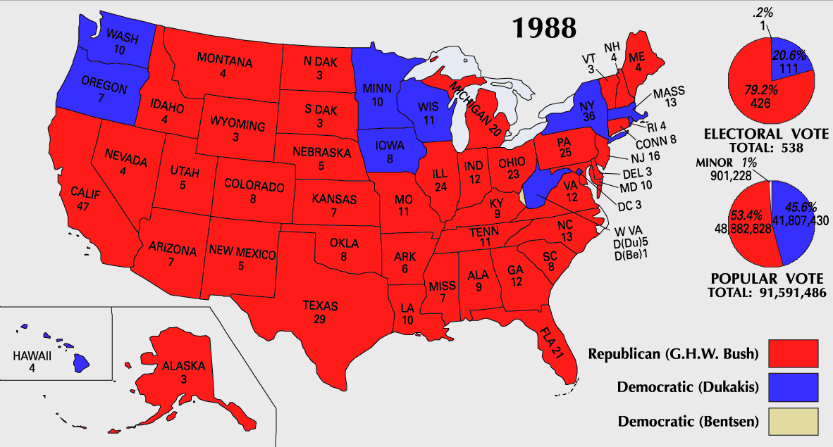
English: 1988 Electoral College Map |
||
| Kilde | https://nationalmap.gov/small_scale/printable/elections.html | ||
| Opphavsperson | Amerikas forente staters geologiske undersøkelse | ||
| Andre versjoner |
|

Lisensiering
This map was obtained from an edition of the National Atlas of the United States. Like almost all works of the U.S. federal government, works from the National Atlas are in the public domain in the United States.
Online access: NationalAtlas.gov | 1970 print edition: Library of Congress, Perry-Castañeda Library
|
Filhistorikk
Klikk på et tidspunkt for å vise filen slik den var på det tidspunktet.
| Dato/klokkeslett | Miniatyrbilde | Dimensjoner | Bruker | Kommentar | |
|---|---|---|---|---|---|
| nåværende | 25. jul. 2007 kl. 12:21 | | 1 182 × 635 (170 KB) | Cardsplayer4life~commonswiki | Reverted to earlier revision |
| 25. jul. 2007 kl. 11:31 |  | 1 182 × 635 (110 KB) | Joseph Solis in Australia~commonswiki | {{PD-USGov-Atlas}} Category:1988 {{US presidential election maps}} | |
| 9. jul. 2007 kl. 03:47 |  | 1 182 × 635 (170 KB) | Cardsplayer4life~commonswiki | {{PD-USGov-Atlas}} {{US presidential election maps}} | |
| 6. jul. 2007 kl. 11:34 |  | 1 182 × 635 (110 KB) | Joseph Solis in Australia~commonswiki | {{PD-USGov-Atlas}} Category:1988 {{US presidential election maps}} | |
| 2. jul. 2007 kl. 04:29 |  | 1 182 × 635 (170 KB) | Cardsplayer4life~commonswiki | {{PD-USGov-Atlas}} {{US presidential election maps}} | |
| 29. jun. 2007 kl. 12:13 |  | 1 182 × 635 (110 KB) | Joseph Solis in Australia~commonswiki | {{PD-USGov-Atlas}} Category:1988 {{US presidential election maps}} | |
| 21. jun. 2007 kl. 23:06 |  | 1 182 × 635 (170 KB) | Cardsplayer4life~commonswiki | {{PD-USGov-Atlas}} Category:1988 {{US presidential election maps}} | |
| 22. jan. 2006 kl. 18:05 |  | 1 182 × 635 (110 KB) | Red devil 666 | {{PD-USGov-Atlas}} |
Filbruk
Den følgende siden bruker denne filen:
Global filbruk
Følgende andre wikier bruker denne filen:
- Bruk i da.wikipedia.org
- Bruk i en.wikipedia.org
- Bruk i nl.wikipedia.org
- Bruk i sv.wikipedia.org
- Bruk i uk.wikipedia.org