
Fil:China-Qinghai.png
Ingen høyere oppløsning tilgjengelig.
China-Qinghai.png (268 × 218 piksler, filstørrelse: 15 KB, MIME-type: image/png)
| Denne filen er fra Wikimedia Commons og kan brukes av andre prosjekter. Informasjonen fra filbeskrivelsessiden vises nedenfor. |
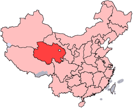
en: Location of Qinghai Province in the People's Republic of China. See Locator maps of province-level divisions of the People's Republic of China for more information.
zh: 青海省在中華人民共和國的位置。另見Locator maps of province-level divisions of the People's Republic of China。

|
Det tillates at dette dokumentet kopieres, distribueres og/eller modifiseres under retningslinjene som beskrevet i GNU fri dokumentasjonslisens, versjon 1.2 eller senere utgave utgitt av Free Software Foundation; med alle seksjoner, uten noen forsidetekster og baksidetekster. En kopi av lisensen er inkludert i avsnittet GNU Free Documentation License. |
| Denne filen er lisensiert under lisensen Creative Commons Navngivelse-DelPåSammeVilkår 3.0 Unported | ||
| ||
| Dette lisensmerket ble lagt til filen som del av lisensoppdateringen av GFDL. |
Filhistorikk
Klikk på et tidspunkt for å vise filen slik den var på det tidspunktet.
| Dato/klokkeslett | Miniatyrbilde | Dimensjoner | Bruker | Kommentar | |
|---|---|---|---|---|---|
| nåværende | 15. jul. 2005 kl. 16:56 | | 268 × 218 (15 KB) | Schaengel89~commonswiki | transparent background |
| 5. jun. 2005 kl. 00:39 |  | 268 × 218 (9 KB) | Ran | '''en''': Location of Qinghai Province in the People's Republic of China. See Category:Locator maps of province-level divisions of the People's Republic of China for more information. '''zh''': 青海省在中華人民共和國的位置。另見[[:C |
Filbruk
Det er ingen sider som bruker denne filen.
Global filbruk
Følgende andre wikier bruker denne filen:
- Bruk i cy.wikipedia.org
- Bruk i da.wikipedia.org
- Bruk i de.wikipedia.org
- Bruk i en.wikipedia.org
- Wikipedia:WikiProject Chinese provinces/Locator maps
- Ledu, Haidong
- Henan Mongol Autonomous County
- Golmud Airport
- Template:Qinghai-geo-stub
- Bayan Har Mountains
- Wenquan, Golmud
- Mangra
- Zêkog County
- Tongren, Qinghai
- Jainca County
- 2008 Tibetan unrest
- Huzhu Tu Autonomous County
- Ping'an, Haidong
- Chengzhong, Xining
- Xireg
- Chengdong, Xining
- Chengbei, Xining
- Datong Hui and Tu Autonomous County
- Huangyuan County
- Huangzhong, Xining
- Hualong Hui Autonomous County
- Haiyan County, Qinghai
- Gangca County
- Menyuan Hui Autonomous County
- Gonghe County
- Tongde County
- Guide County
- Guinan County
- Maqên County
- Banma County
- Gadê County
- Darlag County
- Jigzhi County
- Madoi County
Vis mer global bruk av denne filen.