
Fil:Carnegie Free Library, 300 East South Street, Union (Union County, South Carolina).jpg

Størrelse på denne forhåndsvisningen: 800 × 556 piksler. Andre oppløsninger: 320 × 222 piksler | 640 × 444 piksler | 1 024 × 711 piksler | 1 280 × 889 piksler | 2 560 × 1 778 piksler | 4 611 × 3 202 piksler.
Opprinnelig fil (4 611 × 3 202 piksler, filstørrelse: 1,48 MB, MIME-type: image/jpeg)
| Denne filen er fra Wikimedia Commons og kan brukes av andre prosjekter. Informasjonen fra filbeskrivelsessiden vises nedenfor. |
|
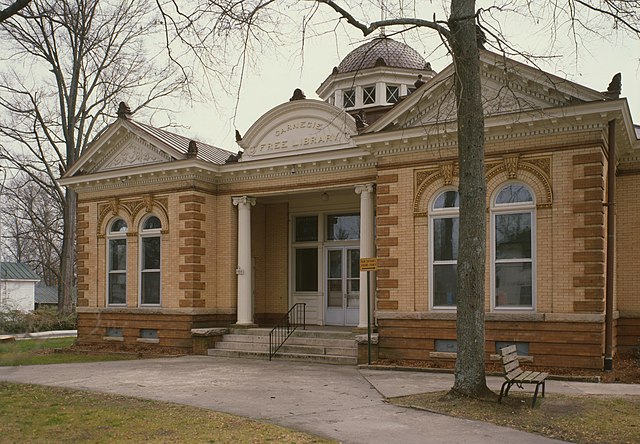
This is an image of a place or building that is listed on the National Register of Historic Places in the United States of America. Its reference number is 83002211. |
| Beskrivelse |
English: Front of the Union Carnegie Free Library, located at 300 E. South Street in Union, South Carolina, United States. Built in 1905, it is part of the South Street-South Church Street Historic District, a historic district that is listed on the National Register of Historic Places. |
|||||||||||||||||||||||||
| Dato | ||||||||||||||||||||||||||
| Kilde |
Library of Congress, Prints and Photograph Division
|
|||||||||||||||||||||||||
| Opphavsperson |
|
|||||||||||||||||||||||||
| Tillatelse (Gjenbruk av denne filen) |
|
|||||||||||||||||||||||||


.jpg)
| Kameraposisjon | | Dette og andre bilder på denne posisjonen på: OpenStreetMap |
|---|
.jpg¶ms=034.713333_N_-081.620667_E_globe:Earth_type:camera__&language=nb)
Filhistorikk
Klikk på et tidspunkt for å vise filen slik den var på det tidspunktet.
| Dato/klokkeslett | Miniatyrbilde | Dimensjoner | Bruker | Kommentar | |
|---|---|---|---|---|---|
| nåværende | 11. feb. 2010 kl. 02:09 | | 4 611 × 3 202 (1,48 MB) | Nyttend | Much higher resolution |
| 21. mar. 2009 kl. 13:40 |  | 585 × 409 (96 KB) | KudzuVine | {{Information |Description={{en|1=Carnegie Free Library, 300 East South Street, Union (Union County, South Carolina) {{PD-USGov-Interior-HABS}} {{HABS| SC,44-UNI,1-13}}}} |Source=http://memory.loc.gov/cgi-bin/displayPhoto.pl?path=/pnp/habshaer/sc/sc0700/s |
Filbruk
Den følgende siden bruker denne filen:
Global filbruk
Følgende andre wikier bruker denne filen:
- Bruk i ar.wikipedia.org
- Bruk i ceb.wikipedia.org
- Bruk i ce.wikipedia.org
- Bruk i cy.wikipedia.org
- Bruk i en.wikipedia.org
- Bruk i es.wikipedia.org
- Bruk i fr.wikipedia.org
- Bruk i ga.wikipedia.org
- Bruk i hu.wikipedia.org
- Bruk i hy.wikipedia.org
- Bruk i it.wikipedia.org
- Bruk i ko.wikipedia.org
- Bruk i pl.wikipedia.org
- Bruk i pt.wikipedia.org
- Bruk i ro.wikipedia.org
- Bruk i ru.wikipedia.org
- Bruk i simple.wikipedia.org
- Bruk i sr.wikipedia.org
- Bruk i sv.wikipedia.org
- Bruk i tr.wikipedia.org
- Bruk i tt.wikipedia.org
- Bruk i ur.wikipedia.org
- Bruk i www.wikidata.org
.jpg)