
Fil:Baltic-Volga-Black-Caspian.png
Ingen høyere oppløsning tilgjengelig.
Baltic-Volga-Black-Caspian.png (340 × 458 piksler, filstørrelse: 210 KB, MIME-type: image/png)
| Denne filen er fra Wikimedia Commons og kan brukes av andre prosjekter. Informasjonen fra filbeskrivelsessiden vises nedenfor. |
Beskrivelse
| Beskrivelse |
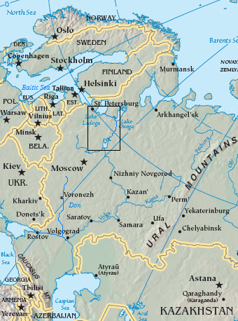
English: Map of the Volga–Baltic Waterway (boxed area).
source map modified with additional labels, box source map modified with additional labels, line drawing, box Original map cropped from https://www.cia.gov/cia/publications/factbook/reference_maps/asia.html |
| Dato | 29. august 2006 (original upload date) |
| Kilde | Transferred from en.wikipedia to Commons. |
| Opphavsperson | The original uploader was Jauntymcd at engelsk Wikipedia. |
Lisensiering
Dette biletet er offentleg eigedom av di det inneheld tilfang som kjem frå Sambandsstatanes Central Intelligence Agency si Allkunnebok over verda.
|
 |
This work is based on a work in the public domain. It has been digitally enhanced and/or modified. This derivative work has been (or is hereby) released into the public domain by its author, jauntymcd. This applies worldwide.
In some countries this may not be legally possible; if so: |
Orginal opplastningslogg
The original description page was here. All following user names refer to en.wikipedia.
- 2006-08-29 23:28 Jauntymcd 340×458×8 (214664 bytes) source map modified with additional labels, box source map modified with additional labels, line drawing, box {{PD-retouched-user|jauntymcd}} Original map cropped from https://www.cia.gov/cia/publications/factbook/reference_maps/asia.html {{PD-USGov-CIA-
Filhistorikk
Klikk på et tidspunkt for å vise filen slik den var på det tidspunktet.
| Dato/klokkeslett | Miniatyrbilde | Dimensjoner | Bruker | Kommentar | |
|---|---|---|---|---|---|
| nåværende | 19. des. 2007 kl. 03:32 | | 340 × 458 (210 KB) | Geanixx | {{Information |Description={{en|source map modified with additional labels, box source map modified with additional labels, line drawing, box Original map cropped from https://www.cia.gov/cia/publications/factbook/reference_maps/asia.html}} |Source=Tran |
Filbruk
Den følgende siden bruker denne filen:
Global filbruk
Følgende andre wikier bruker denne filen:
- Bruk i da.wikipedia.org
- Bruk i en.wikipedia.org
- Bruk i eo.wikipedia.org
- Bruk i es.wikipedia.org
- Bruk i eu.wikipedia.org
- Bruk i fa.wikipedia.org
- Bruk i he.wikipedia.org
- Bruk i it.wikipedia.org
- Bruk i ja.wikipedia.org
- Bruk i nn.wikipedia.org
- Bruk i pl.wikipedia.org
- Bruk i sl.wikipedia.org
- Bruk i uz.wikipedia.org
- Bruk i zh-yue.wikipedia.org
- Bruk i zh.wikipedia.org