
Fil:1855 Colton Map of Central America and Jamaica - Geographicus - CentralAmerica-colton-1855.jpg

Størrelse på denne forhåndsvisningen: 720 × 600 piksler. Andre oppløsninger: 288 × 240 piksler | 576 × 480 piksler | 922 × 768 piksler | 1 229 × 1 024 piksler | 2 458 × 2 048 piksler | 4 000 × 3 333 piksler.
Opprinnelig fil (4 000 × 3 333 piksler, filstørrelse: 4,15 MB, MIME-type: image/jpeg)
| Denne filen er fra Wikimedia Commons og kan brukes av andre prosjekter. Informasjonen fra filbeskrivelsessiden vises nedenfor. |
| J. H. Colton: Central America.
( |
|||||||||||||||||||||
|---|---|---|---|---|---|---|---|---|---|---|---|---|---|---|---|---|---|---|---|---|---|
| Kunstner |
|
||||||||||||||||||||
| Tittel |
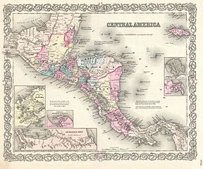
Central America. |
||||||||||||||||||||
| Beskrivelse |
English: A beautiful 1855 first edition example of Colton's map of the Central America and Jamaica. Covers from the Yucatan southeast as far as Panama and north as far as Jamaica. Like most of Colton's North America maps, this map is largely derived from an earlier wall map of North America produced by Colton and D. Griffing Johnson. Features several insets, including the Isthmus of Panama, the Harbor of San Juan de Nicaragua, the Nicaragua Route, Aspinwall City, and the City of Panama. Throughout the map, Colton identifies various cities, towns, forts, rivers, rapids, fords, and an assortment of additional offshore and topographical details. Map is hand colored in pink, green, yellow and blue pastels to define national and regional boundaries. Surrounded by Colton's typical spiral motif border. Dated and copyrighted to J. H. Colton, 1855. Published from Colton's 172 William Street Office in New York City. Issued as page no. 55 in volume 1 of the first edition of George Washington Colton's 1855 Atlas of the World . |
||||||||||||||||||||
| Dato | 1855 (dated) | ||||||||||||||||||||
| Dimensjoner | høyde: 13 in (33 cm); bredde: 16 in (40,6 cm) | ||||||||||||||||||||
| Museumsnummer |
Geographicus link: CentralAmerica-colton-1855 |
||||||||||||||||||||
| Kilde/Fotograf |
Colton, G. W., Colton's Atlas of the World Illustrating Physical and Political Geography, Vol 1, New York, 1855 (First Edition).
|
||||||||||||||||||||
| Tillatelse (Gjenbruk av denne filen) |
|
||||||||||||||||||||

Filhistorikk
Klikk på et tidspunkt for å vise filen slik den var på det tidspunktet.
| Dato/klokkeslett | Miniatyrbilde | Dimensjoner | Bruker | Kommentar | |
|---|---|---|---|---|---|
| nåværende | 23. mar. 2011 kl. 14:34 | | 4 000 × 3 333 (4,15 MB) | BotMultichillT | {{subst:User:Multichill/Geographicus |link=http://www.geographicus.com/P/AntiqueMap/CentralAmerica-colton-1855 |product_name=1855 Colton Map of Central America and Jamaica |map_title=Central America. |description=A beautiful 1855 first edition example of |
Filbruk
Den følgende siden bruker denne filen: