
Fil:Sarajevo Grbavica.JPG
Opprinnelig fil (2 900 × 1 860 piksler, filstørrelse: 3,9 MB, MIME-type: image/jpeg)
| Denne filen er fra Wikimedia Commons og kan brukes av andre prosjekter. Informasjonen fra filbeskrivelsessiden vises nedenfor. |
Beskrivelse
| Beskrivelse |
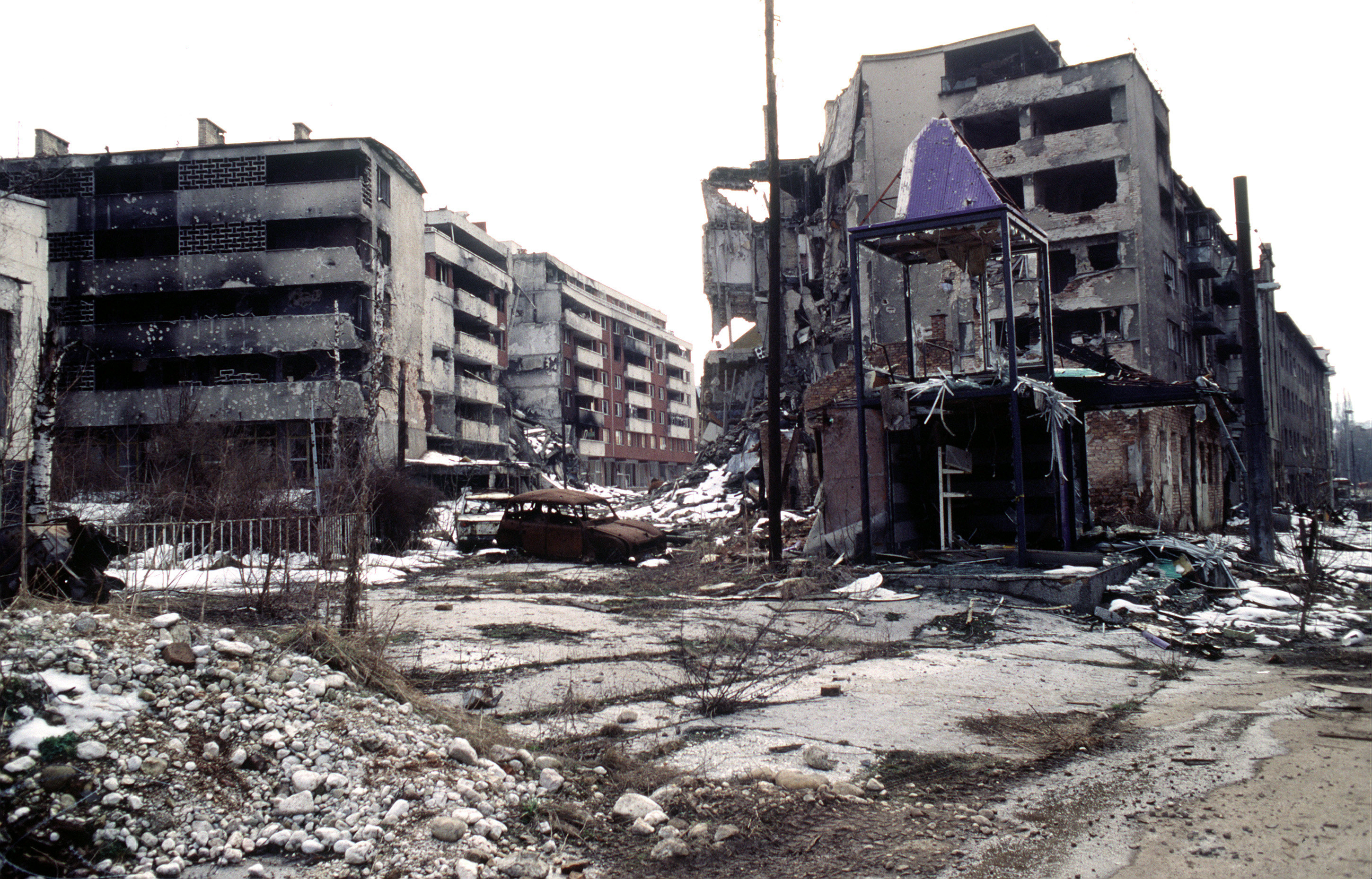
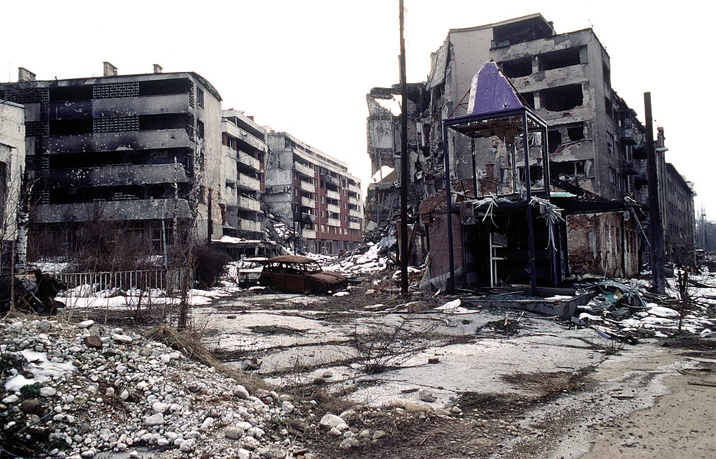
View of Grbavica, a neighbourhood of Sarajevo, approximately 4 months after the signing of the Dayton Peace Accord that officially ended the war in Bosnia. This particular scene shows the part of the neighbourhood located by the left bank of Miljacka river near Vrbanja bridge at the point where Zagrebačka Street and Beogradska Street (later renamed Emerika Bluma Street) meet. Throughout the war (1992-1995), Grbavica was held by the forces of Bosnian Serbs. In relation to the part of Grbavica shown in the photo, Bosnian Muslim (Bosniak) lines were right across on the Miljacka river's right bank. Due to its location in the crossfire between two sides, this part of Grbavica was exposed to constant fire and as a result suffered heavy structural damage. It was basically uninhabitable throughout the war - most of the apartments in the buildings seen in the photo were empty during the war as their occupants fled early on fearing for their safety. These ruins of the apartments and houses were among the last group to be turned over by the Bosnian Serbs to the Bosniaks (a.k.a. Bosnian Muslims) as required by the Dayton Peace Accord, which produced a lasting cease fire and permanent internal borders between two entities - Republika Srpska (Serb entity) and Federation of Bosnia-Herzegovina (Muslim-Croat entity). The white building whose small part (corner) can be seen along the photo's left edge housed the state-owned Unioninvest company before the war. In the years after the war ended, the partially devastated building was rebuilt and to this day houses the Office of the High Representative (OHR), an ad hoc international institution responsible for overseeing implementation of the Dayton Peace Accord (in essence, OHR is Bosnia's highest decision-making institutional body with broad powers). |
| Dato | |
| Kilde | www.dodmedia.osd.mil |
| Opphavsperson | LT. STACEY WYZKOWSKI |
| Tillatelse (Gjenbruk av denne filen) |
Public Domain (PD-USGov-Military) |
| Kameraposisjon | | Dette og andre bilder på denne posisjonen på: OpenStreetMap |
|---|
Lisensiering
This image is a work of a U.S. military or Department of Defense employee, taken or made as part of that person's official duties. As a work of the U.S. federal government, the image is in the public domain in the United States.
|
 |
Filhistorikk
Klikk på et tidspunkt for å vise filen slik den var på det tidspunktet.
| Dato/klokkeslett | Miniatyrbilde | Dimensjoner | Bruker | Kommentar | |
|---|---|---|---|---|---|
| nåværende | 7. apr. 2009 kl. 23:02 | | 2 900 × 1 860 (3,9 MB) | PRODUCER | contrast |
| 23. mar. 2008 kl. 16:37 |  | 2 900 × 1 860 (2,14 MB) | ¡0-8-15! | ||
| 21. nov. 2006 kl. 00:00 |  | 640 × 410 (60 KB) | Bunker~commonswiki | == Summary == {{Information |Description=Overall view of downtown Grbavica, a suburb of Sarajevo. These apartments and houses once occupied by Bosnia Serbs are the last group to be turned over to the Muslims as required by the recent Dayton Peace Accord w |
Filbruk
De følgende 2 sidene bruker denne filen:
Global filbruk
Følgende andre wikier bruker denne filen:
- Bruk i als.wikipedia.org
- Bruk i ar.wikipedia.org
- Bruk i azb.wikipedia.org
- Bruk i be.wikipedia.org
- Bruk i bg.wikipedia.org
- Bruk i bs.wikipedia.org
- Bruk i ca.wikipedia.org
- Bruk i cs.wikipedia.org
- Bruk i de.wikipedia.org
- Bruk i el.wikipedia.org
- Bruk i en.wikipedia.org
- Bruk i en.wikinews.org
- Bruk i en.wikiquote.org
- Bruk i eo.wikipedia.org
- Bruk i es.wikipedia.org
- Bruk i eu.wikipedia.org
- Bruk i fa.wikipedia.org
- Bruk i fr.wikipedia.org
- Bruk i he.wikipedia.org
- Bruk i hr.wikipedia.org
- Bruk i hu.wikipedia.org
- Bruk i id.wikipedia.org
- Bruk i it.wikipedia.org
Vis mer global bruk av denne filen.