
Fil:Mwamongu water source.jpg

Opprinnelig fil (946 × 768 piksler, filstørrelse: 344 KB, MIME-type: image/jpeg)
| Denne filen er fra Wikimedia Commons og kan brukes av andre prosjekter. Informasjonen fra filbeskrivelsessiden vises nedenfor. |
| Beskrivelse |
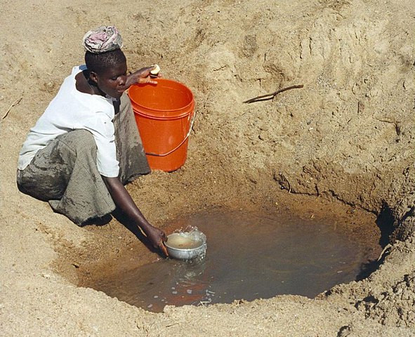
English: Mwamanongu Village water source, Tanzania. "In Meatu district, Shinyanga region, Tanzania, water most often comes from open holes dug in the sand of dry riverbeds, and it is invariably contaminated." .
Français : Point d'eau du village de Mwamanongu, en Tanzanie. "Dans le district de Meatu (région de Shinyanga, Tanzanie), L'eau provient le plus souvent de trous creusés dans le sable de lits de rivières asséchées. Elle est systématiquement contaminée." |
||
| Dato | |||
| Kilde |
http://solarcooking.wikia.com/wiki/Image:Mwamongu_water_source.jpg, |
||
| Opphavsperson | Bob Metcalf | ||
| Tillatelse (Gjenbruk av denne filen) |
|
| Kameraposisjon | | Dette og andre bilder på denne posisjonen på: OpenStreetMap |
|---|
Location note from author: If one goes north from the city of Tabora, follow it to Shinyanga. Shinyanga town is the administrative location of the Shinyanga Region, which includes several districts, Meatu District being one of them. From Shinyanga, go east to find the town of Mhunze, which I think is what I know as Mwanhuze, the District headquarters. It was from Mhunze that we took a Land Rover a bit northwest, I think, perhaps 15 km, to reach Mwamanongu. The driver knew how to get to these villages, but there were no road signs anywhere, nor any landmarks on the flat land, and the 'road' was just a path, often in lousy condition for the rare vehicle that would use it.
Editor's note: Mwanhuze and Mwamanongu are wards in en:Meatu District.[1] Meatu is a trapezoidal region that borders the western end of Lake Eyasi and extends roughly 70 km to the northwest.[2] Mhunze is a ward in en:Bariadi District. Walter Siegmund (talk) 05:02, 14 January 2008 (UTC)

|
This image has been assessed under the valued image criteria and is considered the most valued image on Commons within the scope: Primitive water supply. You can see its nomination here. |
Filhistorikk
Klikk på et tidspunkt for å vise filen slik den var på det tidspunktet.
| Dato/klokkeslett | Miniatyrbilde | Dimensjoner | Bruker | Kommentar | |
|---|---|---|---|---|---|
| nåværende | 13. jan. 2008 kl. 01:39 | | 946 × 768 (344 KB) | Wsiegmund | PE; cropped white borders |
| 13. jan. 2008 kl. 01:38 |  | 1 024 × 768 (149 KB) | Wsiegmund | Upload slightly larger version | |
| 12. jan. 2008 kl. 16:58 |  | 944 × 704 (85 KB) | Wsiegmund | {{Information |Description=Mwamongu Village water source, Tanzania |Source=Wikia:c:solarcooking:Image:Mwamongu_water_source.jpg |Date=2006-06-06 |Author=Bob Metcalf |Permission={{PD-author|Bob Metcalf}} |other_versions= }} |
Filbruk
De følgende 2 sidene bruker denne filen:
Global filbruk
Følgende andre wikier bruker denne filen:
- Bruk i af.wikipedia.org
- Bruk i ar.wikipedia.org
- Bruk i ca.wikipedia.org
- Bruk i da.wikipedia.org
- Bruk i de.wikipedia.org
- Bruk i de.wikibooks.org
- Bruk i de.wiktionary.org
- Bruk i el.wikipedia.org
- Bruk i en.wikipedia.org
- Bruk i en.wikibooks.org
- Bruk i en.wikiversity.org
- Bruk i en.wiktionary.org
- Bruk i es.wikipedia.org
- Bruk i eu.wikipedia.org
- Bruk i fi.wikipedia.org
- Bruk i fr.wikipedia.org
- Bruk i fr.wiktionary.org
- Bruk i ga.wikipedia.org
- Bruk i gur.wikipedia.org
- Bruk i he.wikipedia.org
- Bruk i hi.wikipedia.org
- Bruk i hu.wikibooks.org
- Bruk i id.wikipedia.org
- Bruk i ig.wikipedia.org
- Bruk i io.wiktionary.org
- Bruk i it.wikipedia.org
Vis mer global bruk av denne filen.