
Fil:Map of USA HI full.png
Ingen høyere oppløsning tilgjengelig.
Map_of_USA_HI_full.png (286 × 186 piksler, filstørrelse: 21 KB, MIME-type: image/png)
| Denne filen er fra Wikimedia Commons og kan brukes av andre prosjekter. Informasjonen fra filbeskrivelsessiden vises nedenfor. |
Beskrivelse

|
En vektorversjon av dette bildet (SVG) er tilgjengelig.
Det bør brukes i stedet for punktgrafikkbildet når det er fordelaktig. File:Map of USA HI full.png → File:Map of USA HI full.svg
For mer informasjon om vektorgrafikk les Commons transition to SVG. Se også information about MediaWiki's support of SVG images. |
 |
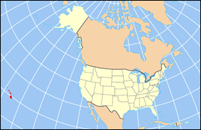
| Beskrivelse | Map of USA with Hawaii highlighted and shown in true position |
| Kilde | http://www.nationalatlas.gov/printable/reference.html |
| Opphavsperson |
Lisensiering
This map was obtained from an edition of the National Atlas of the United States. Like almost all works of the U.S. federal government, works from the National Atlas are in the public domain in the United States.
Online access: NationalAtlas.gov | 1970 print edition: Library of Congress, Perry-Castañeda Library
|
Filhistorikk
Klikk på et tidspunkt for å vise filen slik den var på det tidspunktet.
| Dato/klokkeslett | Miniatyrbilde | Dimensjoner | Bruker | Kommentar | |
|---|---|---|---|---|---|
| nåværende | 2. apr. 2007 kl. 18:30 | | 286 × 186 (21 KB) | MattWright | fix to more standard map colors |
| 1. apr. 2007 kl. 21:09 |  | 286 × 186 (19 KB) | MattWright | {{Information |Description=Map of USA with Hawaii highlighted and shown in true position |Source=http://www.nationalatlas.gov/printable/reference.html |Date= |Author= |Permission= |other_versions= }} Category:Maps of the United States [[Category:Maps |
Filbruk
Det er ingen sider som bruker denne filen.
Global filbruk
Følgende andre wikier bruker denne filen:
- Bruk i bcl.wikipedia.org
- Bruk i bo.wikipedia.org
- Bruk i da.wikipedia.org
- Bruk i en.wikipedia.org
- Bruk i es.wikipedia.org
- Bruk i fa.wikipedia.org
- Bruk i hu.wikipedia.org
- Bruk i id.wikipedia.org
- Bruk i ja.wikipedia.org
- Bruk i ko.wikipedia.org
- Bruk i mrj.wikipedia.org
- Bruk i mr.wikipedia.org
- Bruk i pl.wikipedia.org
- Bruk i pl.wikinews.org
- Bruk i pl.wiktionary.org
- Bruk i ro.wikipedia.org
- Bruk i sv.wikipedia.org
- Bruk i uk.wikipedia.org
Vis mer global bruk av denne filen.