
Fil:Lake Athabasca, Canada.jpg

Størrelse på denne forhåndsvisningen: 800 × 338 piksler. Andre oppløsninger: 320 × 135 piksler | 640 × 270 piksler | 1 156 × 488 piksler.
Opprinnelig fil (1 156 × 488 piksler, filstørrelse: 173 KB, MIME-type: image/jpeg)
| Denne filen er fra Wikimedia Commons og kan brukes av andre prosjekter. Informasjonen fra filbeskrivelsessiden vises nedenfor. |
Beskrivelse
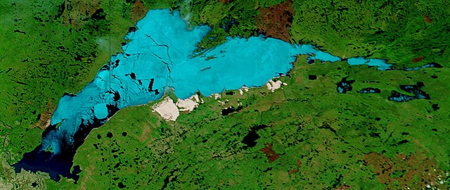
| Beskrivelse | Lake Athabasca, Canada. Lake Athabasca straddles the border between Alberta (west) and Saskatchewan (east) - the black line. In the false-color image, vegetation is green, water is dark blue, and ice (or snow) is light blue. |
| Dato | Visualization Date: 2002-06-18 |
| Kilde | Visible Earth, NASA (extract) |
| Opphavsperson | Jacques Descloitres, MODIS Land Rapid Response Team, NASA/GSFC |
Cropped from the original 4800 x 3600 JPEG (4.4MB) image.
Lisensiering
| This file is in the public domain in the United States because it was solely created by NASA. NASA copyright policy states that "NASA material is not protected by copyright unless noted". (See Template:PD-USGov, NASA copyright policy page or JPL Image Use Policy.) | ||
 |
Warnings:
|
Filhistorikk
Klikk på et tidspunkt for å vise filen slik den var på det tidspunktet.
| Dato/klokkeslett | Miniatyrbilde | Dimensjoner | Bruker | Kommentar | |
|---|---|---|---|---|---|
| nåværende | 18. aug. 2006 kl. 13:37 | | 1 156 × 488 (173 KB) | Feydey | {{Information |Description= Lake Athabasca, Canada. Lake Athabasca straddles the border between Alberta (west) and Saskatchewan (east) - the black line. In the false-color image, vegetation is green, water is dark blue, and ice (or snow) is light blue. |S |
Filbruk
Den følgende siden bruker denne filen:
Global filbruk
Følgende andre wikier bruker denne filen:
- Bruk i af.wikipedia.org
- Bruk i ar.wikipedia.org
- Bruk i arz.wikipedia.org
- Bruk i be.wikipedia.org
- Bruk i bg.wikipedia.org
- Bruk i bn.wikipedia.org
- Bruk i bs.wikipedia.org
- Bruk i ca.wikipedia.org
- Bruk i ceb.wikipedia.org
- Bruk i cv.wikipedia.org
- Bruk i cy.wikipedia.org
- Bruk i da.wikipedia.org
- Bruk i el.wikipedia.org
- Bruk i en.wikipedia.org
- Bruk i eo.wikipedia.org
- Bruk i es.wikipedia.org
- Bruk i eu.wikipedia.org
- Bruk i fa.wikipedia.org
- Bruk i frr.wikipedia.org
- Bruk i fr.wikipedia.org
- Bruk i fy.wikipedia.org
- Bruk i hu.wikipedia.org
- Bruk i hy.wikipedia.org
- Bruk i id.wikipedia.org
- Bruk i incubator.wikimedia.org
- Bruk i it.wikipedia.org
- Bruk i ka.wikipedia.org
- Bruk i kk.wikipedia.org
- Bruk i ky.wikipedia.org
- Bruk i lt.wikipedia.org
- Bruk i lv.wikipedia.org
- Bruk i nl.wikipedia.org
- Bruk i pl.wikipedia.org
- Bruk i pl.wiktionary.org
- Bruk i pnb.wikipedia.org
- Bruk i pt.wikipedia.org
- Bruk i ro.wikipedia.org
- Bruk i ru.wikipedia.org
- Bruk i sv.wikipedia.org
Vis mer global bruk av denne filen.